IMAGES TAKEN NEAR TO
Rhoscolyn, HOLYHEAD, LL65 2DX
Introduction
This page details the photographs taken nearby to LL65 2DX by members of the Geograph project.
The Geograph project started in 2005 with the aim of publishing, organising and preserving representative images for every square kilometre of Great Britain, Ireland and the Isle of Man.

There are currently over 7.5m images from over14,400 individuals and you can help contribute to the project by visiting https://www.geograph.org.uk
Image Map
Images are licensed for reuse under creativecommons.org/licenses/by-sa/2.0
Notes
- Clicking on the map will re-center to the selected point.
- The higher the marker number, the further away the image location is from the centre of the postcode.
Image Listing (18 Images Found)
Images are licensed for reuse under creativecommons.org/licenses/by-sa/2.0
Image
Details
Distance
1
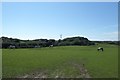
Horses in a field
Beside the road to Rhoscolyn.
Image: © DS Pugh
Taken: 5 Aug 2018
0.01 miles
4
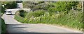
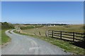
Crossroads of minor road and access tracks
Image: © Eric Jones
Taken: 16 Apr 2008
0.06 miles
5
Footpath to Four Mile Bridge
Leading across from the road to Rhoscolyn.
Image: © DS Pugh
Taken: 5 Aug 2018
0.08 miles
6
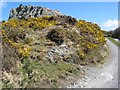
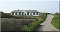
Gabbro outcrop
Certain rock outcrops in the Precambrian of Anglesey are highly enigmatic, notwithstanding their great interest. This rock is what remains of a quarry in a serpentinised gabbro exposure - the interest arising from the idea that magnesium-rich rocks originating as ophiolite, or ocean-floor basalts, have been emplaced during the subduction of the Iapetus Ocean and subsequent continental collision. This view is not held by everybody who has worked on the local geology.
A footpath runs along this track, which gives access to a number of houses towards the coast.
Image: © Jonathan Wilkins
Taken: 26 Apr 2013
0.12 miles
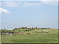
7
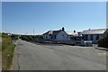
Ysgol Rhoscolyn
The primary school for the rural southern half of the island.
Image: © DS Pugh
Taken: 5 Aug 2018
0.13 miles
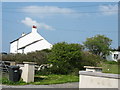
8
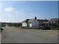
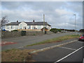
Ysgol Gwenfaen, Rhoscolyn
A view looking south along the lane leading to Rhoscolyn beach, showing the school buildings at right.
Image: © Phil Williams
Taken: 21 Apr 2006
0.13 miles
10
Ysgol Rhoscolyn
One of eight primary schools on Ynys Gybi (Holy Island), it serves the southern rural half of the island. It was previously known as Ysgol Santes Gwenfaen. It has around 110 pupils.
http://www.rhoscolyn.anglesey.sch.uk/
Image: © Eric Jones
Taken: 7 May 2008
0.14 miles