IMAGES TAKEN NEAR TO
TY CROES, LL63 5RJ
Introduction
This page details the photographs taken nearby to LL63 5RJ by members of the Geograph project.
The Geograph project started in 2005 with the aim of publishing, organising and preserving representative images for every square kilometre of Great Britain, Ireland and the Isle of Man.

There are currently over 7.5m images from over14,400 individuals and you can help contribute to the project by visiting https://www.geograph.org.uk
Image Map
Images are licensed for reuse under creativecommons.org/licenses/by-sa/2.0
Notes
- Clicking on the map will re-center to the selected point.
- The higher the marker number, the further away the image location is from the centre of the postcode.
Image Listing (6 Images Found)
Images are licensed for reuse under creativecommons.org/licenses/by-sa/2.0
Image
Details
Distance
2
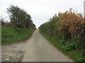
The lane to Aberffraw
A fairly typical lane in the Anglesey countryside where you hope not to meet many oncoming vehicles.
Image: © David Purchase
Taken: 3 Jun 2021
0.18 miles
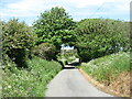
3
Road junction near Llwynysgaw Farm
The road on the left leads to the road leading from Merddyn-y-bit to Rhosbadrig railway bridge.
Image: © Eric Jones
Taken: 4 Nov 2008
0.19 miles
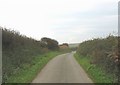
5
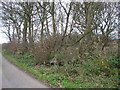
The tree covered ruins of Bryn-Cian-bach
The name Bryn-Cian-bach disappears from the OS map after 1900, which suggests that the cottage was possibly abandoned more than a hundred years ago
Image: © Eric Jones
Taken: 4 Nov 2008
0.20 miles
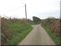
6
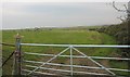
Access to Pole 03/347/003
At least that is what is written on the piece of wood attached to the gate post. The gate and track beyond also gives secondary access to Fferam Bach Farm.
Image: © Eric Jones
Taken: 4 Nov 2008
0.21 miles