IMAGES TAKEN NEAR TO
Stad Y Felin, TY CROES, LL63 5AA
Introduction
This page details the photographs taken nearby to Stad Y Felin, LL63 5AA by members of the Geograph project.
The Geograph project started in 2005 with the aim of publishing, organising and preserving representative images for every square kilometre of Great Britain, Ireland and the Isle of Man.

There are currently over 7.5m images from over14,400 individuals and you can help contribute to the project by visiting https://www.geograph.org.uk
Image Map
Images are licensed for reuse under creativecommons.org/licenses/by-sa/2.0
Notes
- Clicking on the map will re-center to the selected point.
- The higher the marker number, the further away the image location is from the centre of the postcode.
Image Listing (29 Images Found)
Images are licensed for reuse under creativecommons.org/licenses/by-sa/2.0
Image
Details
Distance
1
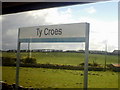
Ty Croes Station
In the beautiful countryside of Anglesey
Image: © Max Fullerton
Taken: 7 May 2005
0.06 miles
2
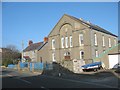
Capel Bryn Du
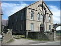
This Calvinistic Methodist chapel was built in 1901. It is the fourth chapel to occupy the site, the first having been built in 1793, the second in 1814 and the third in 1860. The present chapel was built to seat 500 people and is a Grade II registered building. A manse and a caretaker's house were added to the site. It was in the 1793 chapel that John Elias, the High Calvinist and High Tory, nicknamed the "Anglesey Pope", who dragooned the Anglesey Calvinists with threats of excommunication and eternal damnation to oppose both the Catholic Emancipation Act of 1831 and the 1832 Reform Act, preached his first sermon on the island. He must have been spinning in his grave at Llanfaes when, during WWII, the brethren invited an evacuated Liverpool Roman Catholic Primary School to use the chapel on a daily basis for the duration of the war.
Image
Image: © Eric Jones
Taken: 3 Nov 2008
0.06 miles
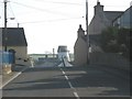
4
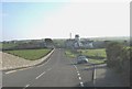
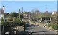
The road to Ty Croes Station west of Melin y Bont and the Queen's Head PH
Image: © Eric Jones
Taken: 3 Nov 2008
0.07 miles
5
Capel Bryn Du
For information about this chapel, see Image
Image: © David Purchase
Taken: 3 Jun 2021
0.08 miles
6
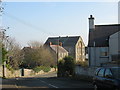
Bend in the road near Bryn Du Calvinistic Methodist Chapel
The large house next to the chapel was the manse.
Image: © Eric Jones
Taken: 3 Nov 2008
0.08 miles
7
The Bryn Du War Memorial in the Bryn Du Chapel Cemetery
The memorial is in the form of a broken column.
Image: © Eric Jones
Taken: 3 Nov 2008
0.09 miles
9
View over the brow of the hill towards Melin y Bont Mill
This mill has been converted into a residence.
Image: © Eric Jones
Taken: 3 Nov 2008
0.10 miles
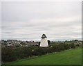
10
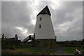
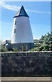
Melin Y Bont, Bryn Du
Converted windmill (Grade II listed), Melin Y Bont (mill by the bridge), Bryn Du. One of only a few mills built to use water and windpower.
Image: © gordon
Taken: 3 Nov 2007
0.10 miles