IMAGES TAKEN NEAR TO
Capel Mawr, BODORGAN, LL62 5NT
Introduction
This page details the photographs taken nearby to LL62 5NT by members of the Geograph project.
The Geograph project started in 2005 with the aim of publishing, organising and preserving representative images for every square kilometre of Great Britain, Ireland and the Isle of Man.

There are currently over 7.5m images from over14,400 individuals and you can help contribute to the project by visiting https://www.geograph.org.uk
Image Map
Images are licensed for reuse under creativecommons.org/licenses/by-sa/2.0
Notes
- Clicking on the map will re-center to the selected point.
- The higher the marker number, the further away the image location is from the centre of the postcode.
Image Listing (7 Images Found)
Images are licensed for reuse under creativecommons.org/licenses/by-sa/2.0
Image
Details
Distance
1
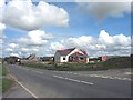
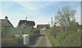
New bungalow under construction alongside the B4422 at Capel Mawr
Image: © Eric Jones
Taken: 2 May 2008
0.03 miles
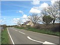
5
Cottages in a cul-de-sac at Capel Mawr
Their names are listed on the road sign. Ty Rodyn means (lime) kiln house and the "felin" element in the other two names refer to the ruined mill sited in the field behind.
Image: © Eric Jones
Taken: 2 May 2008
0.20 miles
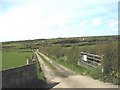
6
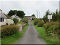
Where's the windmill?
A short lane and public footpath at Capel Mawr, but where is the windmill? My slightly out of date OS map shows one somewhere near the clump of trees to the left, but I assume that it has been demolished as it isn't shown on the current map.
Image: © Gordon Hatton
Taken: 28 Sep 2023
0.22 miles
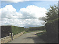
7
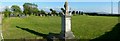
Capel Mawr, Bodorgan.
A view of the site of a very large Chapel, that gave the hamlet its name "Capel Mawr".
Image: © Stephen Elwyn RODDICK
Taken: 30 May 2006
0.25 miles