IMAGES TAKEN NEAR TO
Hermon, BODORGAN, LL62 5LN
Introduction
This page details the photographs taken nearby to LL62 5LN by members of the Geograph project.
The Geograph project started in 2005 with the aim of publishing, organising and preserving representative images for every square kilometre of Great Britain, Ireland and the Isle of Man.

There are currently over 7.5m images from over14,400 individuals and you can help contribute to the project by visiting https://www.geograph.org.uk
Image Map
Images are licensed for reuse under creativecommons.org/licenses/by-sa/2.0
Notes
- Clicking on the map will re-center to the selected point.
- The higher the marker number, the further away the image location is from the centre of the postcode.
Image Listing (65 Images Found)
Images are licensed for reuse under creativecommons.org/licenses/by-sa/2.0
Image
Details
Distance
1
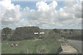
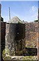
A trig pillar at the bottom the garden at Pen Boncan
The height here is 63.23m
Image: © Eric Jones
Taken: 2 May 2008
0.02 miles
2
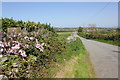
Lane and trig pillar near Hermon
The trig pillar seen on the left is at the end of a private garden next to an unnamed lane heading towards Hermon.
Image: © Jeff Buck
Taken: 3 May 2017
0.03 miles
3
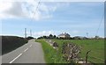
The ascent to Pen Boncan
Pen Boncan means "top of the tump". The literary form is "poncen" but in the North West Wales dialect the "e" turns into an "a".
Image: © Eric Jones
Taken: 2 May 2008
0.03 miles
4
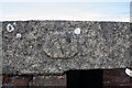
North Wales WWII defences: RAF Bodorgan, Anglesey - Hermon pillbox (9)
-
Pillbox (unclassified): DoB ID: S0003168
A small raised panel on the lintel over the entrance doorway has what appears to be a horse's head inscribed upon it. Presumably some sort of reference to the unit who may have built or manned the pillbox.
Image
Image: © Mike Searle
Taken: 13 May 2017
0.03 miles
5
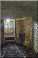
North Wales WWII defences: RAF Bodorgan, Anglesey - Hermon pillbox (8)
-
Pillbox (unclassified): DoB ID: S0003168
The machine gun pedestal in the centre of the gun pit from the crew shelter entrance.
Image
Image: © Mike Searle
Taken: 13 May 2017
0.03 miles
6
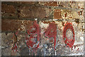
North Wales WWII defences: RAF Bodorgan, Anglesey - Hermon pillbox (10)
-
Pillbox (unclassified): DoB ID: S0003168
Interior view from the crew shelter in the middle of the structure showing the fire grate and above that on the wall, the painted date of '1940' in figures of raised cement. The date indicates the likelihood that this was among the first of the defensive structures to be built at Bodorgan.
Image
Image: © Mike Searle
Taken: 13 May 2017
0.03 miles
7
North Wales WWII defences: RAF Bodorgan, Anglesey - Hermon pillbox (11)
-
Pillbox (unclassified): DoB ID: S0003168
Close-up of the 1940 date showing that it was first made with precast figures that were then cemented in place on the wall.
Image
Image: © Mike Searle
Taken: 13 May 2017
0.03 miles
8

Pillbox, Near Hermon
Associated with RAF Bodorgan (defunct).
Image: © Chris Andrews
Taken: 16 Mar 2014
0.03 miles
9
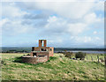
Pill box in field beside minor road
A World War II, brick-built pill box in a field close to the small settlement at Hermon.
Mike Searle describes it as being part of the defences for RAF Bodorgan and has a splendid series of photographs showing the feature in detail, beginning with - https://www.geograph.org.uk/photo/5085777.
Image: © Trevor Littlewood
Taken: 8 Oct 2019
0.03 miles
10

North Wales WWII defences: RAF Bodorgan, Anglesey - Hermon pillbox (7)
-
Pillbox (unclassified): DoB ID: S0003168
Image
Image: © Mike Searle
Taken: 15 Aug 2016
0.03 miles