IMAGES TAKEN NEAR TO
Llangristiolus, BODORGAN, LL62 5DY
Introduction
This page details the photographs taken nearby to LL62 5DY by members of the Geograph project.
The Geograph project started in 2005 with the aim of publishing, organising and preserving representative images for every square kilometre of Great Britain, Ireland and the Isle of Man.

There are currently over 7.5m images from over14,400 individuals and you can help contribute to the project by visiting https://www.geograph.org.uk
Image Map
Images are licensed for reuse under creativecommons.org/licenses/by-sa/2.0
Notes
- Clicking on the map will re-center to the selected point.
- The higher the marker number, the further away the image location is from the centre of the postcode.
Image Listing (17 Images Found)
Images are licensed for reuse under creativecommons.org/licenses/by-sa/2.0
Image
Details
Distance
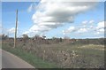
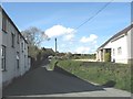
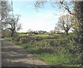
1
Sharp bend in the road near Penrhos-engan
Image: © Eric Jones
Taken: 2 May 2008
0.02 miles
4
Approaching Capel Horeb along the footpath from Henblas
Image: © Eric Jones
Taken: 2 May 2008
0.08 miles
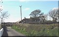
5
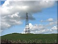
Electricity transmission line at Llangristiolus
Image: © Eric Jones
Taken: 2 May 2008
0.09 miles
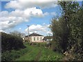
6
Capel Horeb, Llangristiolus
This is a Calvinistic Methodist chapel.
Image: © Eric Jones
Taken: 2 May 2008
0.09 miles
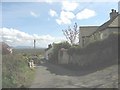
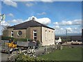
7
Houses on the Carboniferous Limestone scarp
This scarp, much rockier further west, is the eastern boundary of a narrow belt of Carboniferous Limestone which borders on the Coal Measures of the Malltraeth Marsh.
Image: © Eric Jones
Taken: 2 May 2008
0.11 miles
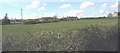
8
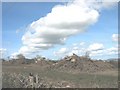
Ready for burning - cleared scrub at Bryn Coch
Image: © Eric Jones
Taken: 2 May 2008
0.12 miles