IMAGES TAKEN NEAR TO
Brynsiencyn, LLANFAIRPWLLGWYNGYLL, LL61 6SQ
Introduction
This page details the photographs taken nearby to LL61 6SQ by members of the Geograph project.
The Geograph project started in 2005 with the aim of publishing, organising and preserving representative images for every square kilometre of Great Britain, Ireland and the Isle of Man.

There are currently over 7.5m images from over14,400 individuals and you can help contribute to the project by visiting https://www.geograph.org.uk
Image Map
Images are licensed for reuse under creativecommons.org/licenses/by-sa/2.0
Notes
- Clicking on the map will re-center to the selected point.
- The higher the marker number, the further away the image location is from the centre of the postcode.
Image Listing (10 Images Found)
Images are licensed for reuse under creativecommons.org/licenses/by-sa/2.0
Image
Details
Distance
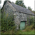
1
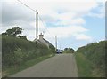
Approaching the hilltop and Y Berth cottage
Image: © Eric Jones
Taken: 7 Jun 2008
0.02 miles
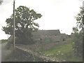
5
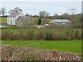
Melin Bodowyr
Farm on the site of an old mill.
Image: © Oliver Dixon
Taken: 8 Apr 2016
0.20 miles
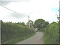
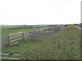
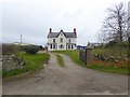
8
Lane south-west of Llyslew
Llyslew farmhouse can be seen in the centre of the photograph.
Image: © Eric Jones
Taken: 7 Jun 2008
0.22 miles
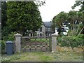
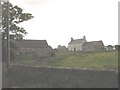
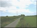
10
Llys Lew Farmhouse
See also Image One of the gateposts and a couple of trees have gone in the last eight years, and the house has received a good lick of paint.
Image: © Oliver Dixon
Taken: 8 Apr 2016
0.24 miles