IMAGES TAKEN NEAR TO
Llanddaniel, GAERWEN, LL60 6HE
Introduction
This page details the photographs taken nearby to LL60 6HE by members of the Geograph project.
The Geograph project started in 2005 with the aim of publishing, organising and preserving representative images for every square kilometre of Great Britain, Ireland and the Isle of Man.

There are currently over 7.5m images from over14,400 individuals and you can help contribute to the project by visiting https://www.geograph.org.uk
Image Map
Images are licensed for reuse under creativecommons.org/licenses/by-sa/2.0
Notes
- Clicking on the map will re-center to the selected point.
- The higher the marker number, the further away the image location is from the centre of the postcode.
Image Listing (6 Images Found)
Images are licensed for reuse under creativecommons.org/licenses/by-sa/2.0
Image
Details
Distance
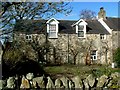
2
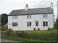
Ty'n L?n, a former farmhouse
The original farmhouse was the right hand two thirds of the building which was extended in the 1970s.
Image: © Robin Drayton
Taken: 9 Sep 2007
0.22 miles
3
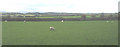
Bullocks grazing
A field near Llanddaniel Fab with an view over southern Anglesey towards Snowdonia. The valley in the centre of the horizon is Image
Image: © Robin Drayton
Taken: 16 Aug 2008
0.22 miles
4
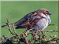
Male house sparrow, Llanddaniel Fab, Anglesey
The house sparrow came number one for the UK in the RSPB Big Garden Birdwatch 2017.
On Anglesey it was number two to the starling.
Image: © Robin Drayton
Taken: 27 Mar 2017
0.22 miles
5
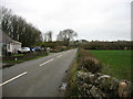
Minor road leading to Llanfair PG from the south-west
Image: © David Purchase
Taken: 13 Dec 2019
0.24 miles
6
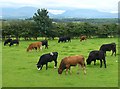
Former farmhouse at Tyddyn Isaf
Land attached to this old house is being managed for wildlife - tree planting, a small pool, and meadows cut for hay.
Image: © Ken Walton
Taken: 8 Feb 2001
0.24 miles