IMAGES TAKEN NEAR TO
Llansadwrn, MENAI BRIDGE, LL59 5SN
Introduction
This page details the photographs taken nearby to LL59 5SN by members of the Geograph project.
The Geograph project started in 2005 with the aim of publishing, organising and preserving representative images for every square kilometre of Great Britain, Ireland and the Isle of Man.

There are currently over 7.5m images from over14,400 individuals and you can help contribute to the project by visiting https://www.geograph.org.uk
Image Map
Images are licensed for reuse under creativecommons.org/licenses/by-sa/2.0
Notes
- Clicking on the map will re-center to the selected point.
- The higher the marker number, the further away the image location is from the centre of the postcode.
Image Listing (9 Images Found)
Images are licensed for reuse under creativecommons.org/licenses/by-sa/2.0
Image
Details
Distance
2
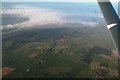
Anglesey over Llansadwrn and Hafotty Covert: aerial 2015
From about 4,000 feet in a Cessna 150 returning to UK from Dublin (Weston).
Image: © Chris
Taken: 2 Oct 2015
0.16 miles
3
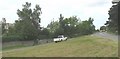
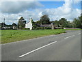
The junction with the B 5109 at Llansadwrn
Image: © Eric Jones
Taken: 8 Aug 2008
0.16 miles
4
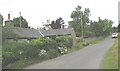
Traditional cottage and a stretch of disused road at the eastern end of Llansadwrn
Image: © Eric Jones
Taken: 8 Aug 2008
0.16 miles
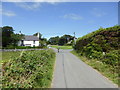
5
Road junction at Llansadwrn
Taken from the B5109.
Image: © David Medcalf
Taken: 27 Sep 2007
0.17 miles
6

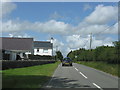
Llansadwrn
Looking west towards Llansadwrn from the B5109.
Image: © Keith Williamson
Taken: 27 Oct 2005
0.18 miles
8
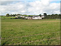
Houses at Llansadwrn
The village covers a wide area, but this is the main concentration of houses.
Image: © David Medcalf
Taken: 27 Sep 2007
0.21 miles
9
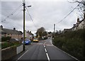
Llansadwrn village
Llansadwrn is a two centred settlement. This western part is a piece of ribbon development close to the junction with the B5109. a streetscape dominated by poles and cables.
Image: © Christopher Hall
Taken: 25 Oct 2014
0.23 miles