IMAGES TAKEN NEAR TO
Llangoed, BEAUMARIS, LL58 8LY
Introduction
This page details the photographs taken nearby to LL58 8LY by members of the Geograph project.
The Geograph project started in 2005 with the aim of publishing, organising and preserving representative images for every square kilometre of Great Britain, Ireland and the Isle of Man.

There are currently over 7.5m images from over14,400 individuals and you can help contribute to the project by visiting https://www.geograph.org.uk
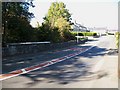
Image Map
Images are licensed for reuse under creativecommons.org/licenses/by-sa/2.0
Notes
- Clicking on the map will re-center to the selected point.
- The higher the marker number, the further away the image location is from the centre of the postcode.
Image Listing (17 Images Found)
Images are licensed for reuse under creativecommons.org/licenses/by-sa/2.0
Image
Details
Distance

2
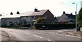
Bryn Paun Housing Estate, Llangoed
Bryn Paen means Peacock Hill.
Image: © Eric Jones
Taken: 17 Oct 2009
0.09 miles
4
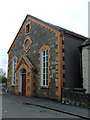
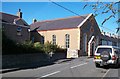
Jerusalem chapel in Llangoed
The Jerusalem Baptist Chapel in Llangoed was built in 1862
Image: © Nigel Williams
Taken: 13 May 2006
0.14 miles
5
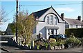
The former Ysgoldy y Rhyd Chapel, Beaumaris Road, Llangoed
This former Calvinist chapel, built at the cost of £750 in 1897 was a branch of Capel Ty Rhys situated near to St Cawrdaf Church. It has now been converted into a private dwelling.
Image
Image: © Eric Jones
Taken: 17 Oct 2009
0.16 miles
6
Pont y Brenhin at the southern end of Llangoed
Pont y Brenhin (=kingsbridge) carries the B5109 across Afon Brenhin (=king's stream). Afon Brenhin is a major tributary of Afon Lleiniog.
Image: © Eric Jones
Taken: 17 Oct 2009
0.16 miles
7
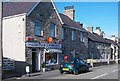
Village shop and Post Office at Llangoed
The shop is known as Morley House. The business has been in the hands of the Pritchard Family for a number of generations.
Image: © Eric Jones
Taken: 17 Oct 2009
0.17 miles
8
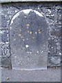
Parish boundary stone, Llangoed
This stone marks the boundary between the parishes of Llanfaes & Llangoed. The stone is located on Pont Y Brehnin (Kings Bridge) over Afon Brenhin, just as you enter Llangoed on the B5109. The inscription on the stone reads: 1863 LLANFAES P LLANGOED P.
Image: © Meirion
Taken: 16 Oct 2010
0.17 miles
9
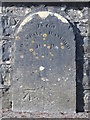
Boundary stone and bench mark on Pont y Brenhin
This boundary stone dated 1863 stands on Pont y Brenhin over Afon y Brenhin, just south of Llangoed. It marks the boundary between Llangoed and Llanfaes, and also has an Ordnance Survey bench mark.
Image: © John S Turner
Taken: 19 Mar 2009
0.18 miles
10
Capel Jeriwsalem, Beaumaris Road, Llangoed
This Welsh Baptist chapel (Capel y Bedyddwyr) was built in 1862, replacing an earlier chapel of 1802. The chapel remains open.
Image: © Eric Jones
Taken: 20 Aug 2009
0.18 miles