IMAGES TAKEN NEAR TO
Bryn Lane, BEAUMARIS, LL58 8EF
Introduction
This page details the photographs taken nearby to Bryn Lane, LL58 8EF by members of the Geograph project.
The Geograph project started in 2005 with the aim of publishing, organising and preserving representative images for every square kilometre of Great Britain, Ireland and the Isle of Man.

There are currently over 7.5m images from over14,400 individuals and you can help contribute to the project by visiting https://www.geograph.org.uk
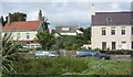
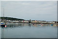
Image Map
Images are licensed for reuse under creativecommons.org/licenses/by-sa/2.0
Notes
- Clicking on the map will re-center to the selected point.
- The higher the marker number, the further away the image location is from the centre of the postcode.
Image Listing (397 Images Found)
Images are licensed for reuse under creativecommons.org/licenses/by-sa/2.0
Image
Details
Distance
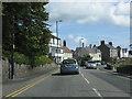
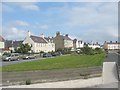
4
Terraced housing either side of the junction with Chapel Street
Image: © Eric Jones
Taken: 24 Sep 2008
0.04 miles
6
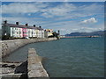
Beaumaris: shoreline view
Looking towards the town centre from the west. The small slipway in front of us will go into the mud at lower tides.
Image: © Chris Downer
Taken: 10 Aug 2013
0.04 miles
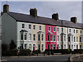
7
Colourful Terrace
Painted houses on sea front
Image: © David C Williams
Taken: 17 Sep 2004
0.04 miles
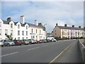
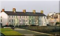
8
The West End
The West End, dated 1869
Image: © Arthur C Harris
Taken: 18 Apr 2013
0.05 miles
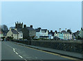
10

Slipway and Foreshore, Beaumaris
Looking from the top of the slipway towards Chimney Corner at the end of Castle Street.
Image: © Paul Harrop
Taken: 13 Jul 2009
0.05 miles