IMAGES TAKEN NEAR TO
Dol Helyg, BANGOR, LL57 3YA
Introduction
This page details the photographs taken nearby to Dol Helyg, LL57 3YA by members of the Geograph project.
The Geograph project started in 2005 with the aim of publishing, organising and preserving representative images for every square kilometre of Great Britain, Ireland and the Isle of Man.

There are currently over 7.5m images from over14,400 individuals and you can help contribute to the project by visiting https://www.geograph.org.uk
Image Map
Images are licensed for reuse under creativecommons.org/licenses/by-sa/2.0
Notes
- Clicking on the map will re-center to the selected point.
- The higher the marker number, the further away the image location is from the centre of the postcode.
Image Listing (28 Images Found)
Images are licensed for reuse under creativecommons.org/licenses/by-sa/2.0
Image
Details
Distance
1
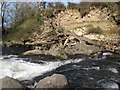
Eroding glacial deposits, Afon Ogwen
At this point the Afon Ogwen has been engineered to make a slight drop, but it is not obvious whether that is the cause of the erosion of the thick glacial deposits which make a cliff here. I suspect that the cliff is actually a section across a drumlin running parallel to the Menai Strait which constrained the flow of ice during the last glacial maximum. A fantastic scene, with a dead tree obviously stranded during a flood in recent years. It is not obvious from the image that there are houses at the top of the bank.
Image: © Jonathan Wilkins
Taken: 25 Mar 2017
0.09 miles
2
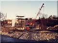
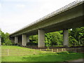
Constructing the A55 viaduct over Afon Ogwen
Image: © Chris Andrews
Taken: Unknown
0.09 miles
3
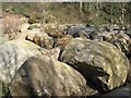
A collection of erratic boulders
Locally-occurring, glacial-erratic boulders have been collected together to make a low rampart adjacent to a low weir structure in the Afon Ogwen. Deep scratches and gouge-marks indicate that they have been moved to their present position by machine, though that presented a significant task as the larger ones are 2-3 metres long and must weigh many tons. Various rock types are represented, but most are of rhyolite and sandstone suggesting an origin high in the Ogwen Valley, from where they were transported in the powerful ice-stream occupying the valley at the last glacial maximum. See also Image
Image: © Jonathan Wilkins
Taken: 25 Mar 2017
0.12 miles
6
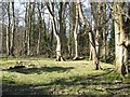
Woodland, Ogwen valley
A small wood sheltered by the valley and adjacent to the Afon Ogwen. The scene is well lit while the trees are in their leafless, Winter condition.
Image: © Jonathan Wilkins
Taken: 25 Mar 2017
0.13 miles
7
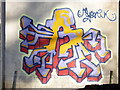
Some colourful graffiti under the A55 flyover, Tal-y-bont
This graffiti can be viewed from the footpath that goes under the flyover.
Image: © Meirion
Taken: 29 Nov 2010
0.13 miles

9
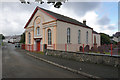
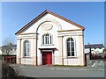
Capel Bethlehem, Tal-y-Bont
It is in good condition, but it is difficult to tell whether it is still active.
Image: © Bill Boaden
Taken: 18 Sep 2015
0.14 miles