IMAGES TAKEN NEAR TO
Glanogwen, BANGOR, LL57 3PG
Introduction
This page details the photographs taken nearby to Glanogwen, LL57 3PG by members of the Geograph project.
The Geograph project started in 2005 with the aim of publishing, organising and preserving representative images for every square kilometre of Great Britain, Ireland and the Isle of Man.

There are currently over 7.5m images from over14,400 individuals and you can help contribute to the project by visiting https://www.geograph.org.uk
Image Map
Images are licensed for reuse under creativecommons.org/licenses/by-sa/2.0
Notes
- Clicking on the map will re-center to the selected point.
- The higher the marker number, the further away the image location is from the centre of the postcode.
Image Listing (59 Images Found)
Images are licensed for reuse under creativecommons.org/licenses/by-sa/2.0
Image
Details
Distance
1
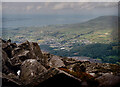
The slate quarrying town of Bethesda from the summit of Carnedd y Filiast
Image: © Eric Jones
Taken: 18 Jul 1998
0.01 miles
2
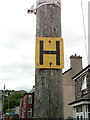
Hydrant sign on telephone pole on Pant Road, Bethesda
Image: © Meirion
Taken: 15 May 2020
0.06 miles
7
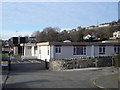
Ysgol Abercaseg
Abercaseg infants school Bethesda.
Image: © idris
Taken: 14 Mar 2007
0.09 miles
8
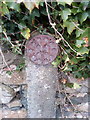
Remains of an old reflective roadside disc, Bethesda
Image: © Meirion
Taken: 15 Oct 2019
0.09 miles
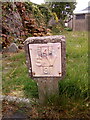
9
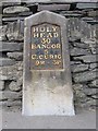
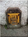
Old Milestone by the A5, High Street, Bethesda parish
Telford Plate by the A5, in parish of Bethesda (Gwynedd District), by Bethesda Football Club against stone wall, West side of road.
Inscription reads:-
HOLY-
HEAD
30
BANGOR
5
C.CURIG
9m - 3F.
Carved bench mark lower left face.
Grade II listed by Cadw.
Reference Number: 18379 https://cadwpublic-api.azurewebsites.net/reports/listedbuilding/FullReport?lang=&id=18379
Surveyed
Milestone Society National ID: CAE_HH30
Image: © Milestone Society
Taken: Unknown
0.11 miles
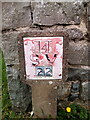
10
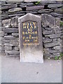
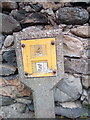
A Telford milestone (Holyhead 30), Bethesda
This is one of Thomas Telford's milestones located along the original London - Holyhead Road (A5). This one indicates that Holyhead is 30 miles away. This milestone is also inscribed with a cut mark benchmark which is recorded in the Ordnance Survey database at a height of 147.0874m above the Newlyn datum. See also Image
Image: © Meirion
Taken: 23 Sep 2011
0.11 miles