IMAGES TAKEN NEAR TO
Menai Avenue, BANGOR, LL57 2HH
Introduction
This page details the photographs taken nearby to Menai Avenue, LL57 2HH by members of the Geograph project.
The Geograph project started in 2005 with the aim of publishing, organising and preserving representative images for every square kilometre of Great Britain, Ireland and the Isle of Man.

There are currently over 7.5m images from over14,400 individuals and you can help contribute to the project by visiting https://www.geograph.org.uk
Image Map
Images are licensed for reuse under creativecommons.org/licenses/by-sa/2.0
Notes
- Clicking on the map will re-center to the selected point.
- The higher the marker number, the further away the image location is from the centre of the postcode.
Image Listing (158 Images Found)
Images are licensed for reuse under creativecommons.org/licenses/by-sa/2.0
Image
Details
Distance
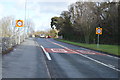
2
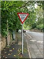
Ildiwch / Give Way sign at road junction, Bangor
Image: © Meirion
Taken: 1 Sep 2023
0.03 miles
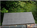
3
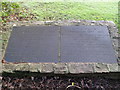
Menai Woods Memorial, Bangor
This pair of slate tablets are to be found near the Bangor-side entrance to Menai Woods, just off Holyhead Road in Upper Bangor.
There is a Welsh and English tablet.
The tablets read:
COED MENAI
ANRHEG CORONI 1953
Trosglwyddwyd rhyddfraint y tir lle mae'r
coed hyn i Ddinas Bangor gan
SYR MICHAEL DUFF
Y Faenol
I ddathlu Coroni EI Mawrhydi Y
FRENHINES ELIZABETH II are Fehefin yr 2 fed,1953.
Dadorchuddiwyd y Dabled hon gan ei Deilyngdod y
Maer, Yr Henadur HUGH J. JONES. Y.H.
Hydref 1953.
MENAI WOODS
CORONATION GIFT 1953
The freehold of the land occupied by these woods
was conveyed to the City of Bangor by
SIR MICHAEL DUFF
of Vaynol Park
To commemorate the coronation of Her Majesty
QUEEN ELIZABETH II on the 2nd June, 1953.
This tablet was unveiled by His Worship
the Mayor of Bangor Alderman HUGH J. JONES. J.P.
October 1953.
Menai woods is a narrow strip of woodland running parallel to Holyhead Road. There is a narrow footpath that winds it way through the woods. There is an entrance on the Bangor-side (where the tablets are) and near the Normal College.
Image: © Meirion
Taken: 13 Jan 2012
0.03 miles
4
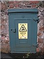
Old electrical cabinet on Victoria Drive, Bangor
Image: © Meirion
Taken: 27 Aug 2019
0.03 miles
6
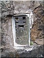
Flush bracket S0338 on Holyhead Road, Bangor
This flush bracket located on Holyhead Road on the outskirts of Bangor is shown in the Ordnance Survey database as being 28.7150m above the Newlyn datum.
Image: © Meirion
Taken: 25 Aug 2010
0.05 miles
7
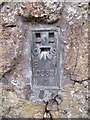
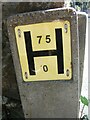
Flush bracket S0337 on Holyhead Road, Bangor
This flush bracket is located at a wall junction on Holyhead Road in Upper Bangor and is shown in the Ordnance Survey database as being 52.3440m above the Newlyn datum.
Image: © Meirion
Taken: 25 Aug 2010
0.05 miles
8
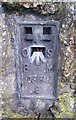
Ordnance Survey Flush Bracket (S0337)
This OS Flush Bracket can be found on the wall SE side of the road. It marks a point 20.786m above mean sea level.
Image: © Adrian Dust
Taken: 31 Jan 2017
0.05 miles
10
A bilingual plaque recording the bequest of the Wartski Fields to the People of Bangor
These fields were bequeathed to the city and people of Bangor by his widow, Winifred Marie, in memory of Isodore Wartski, a former mayor of the city and one of its leading businessmen.
Image
Image: © Eric Jones
Taken: 8 Sep 2008
0.06 miles