IMAGES TAKEN NEAR TO
Victoria Park, BANGOR, LL57 2EW
Introduction
This page details the photographs taken nearby to Victoria Park, LL57 2EW by members of the Geograph project.
The Geograph project started in 2005 with the aim of publishing, organising and preserving representative images for every square kilometre of Great Britain, Ireland and the Isle of Man.

There are currently over 7.5m images from over14,400 individuals and you can help contribute to the project by visiting https://www.geograph.org.uk
Image Map
Images are licensed for reuse under creativecommons.org/licenses/by-sa/2.0
Notes
- Clicking on the map will re-center to the selected point.
- The higher the marker number, the further away the image location is from the centre of the postcode.
Image Listing (206 Images Found)
Images are licensed for reuse under creativecommons.org/licenses/by-sa/2.0
Image
Details
Distance
1
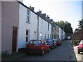
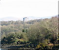
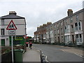
Field Street, Upper Bangor
There are several streets of these Victorian terraced houses in Upper Bangor and their proximity to the University makes them popular as student housing.
Image: © David Stowell
Taken: 17 Aug 2005
0.04 miles
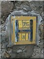
5
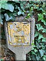
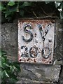
Old sluice valve marker on Holyhead Road, Bangor
Image: © Meirion
Taken: 18 Jul 2019
0.08 miles
6
Old sluice valve marker on Holyhead Road, Bangor
Image: © Meirion
Taken: 27 Aug 2019
0.08 miles
7
Holyhead Road, Bangor
Many of these houses near to the main university building are rooming houses for students.
Image: © Eric Jones
Taken: 8 Sep 2008
0.08 miles
8
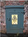
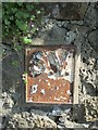
Old electrical cabinet on Victoria Drive, Bangor
Image: © Meirion
Taken: 27 Aug 2019
0.08 miles