IMAGES TAKEN NEAR TO
LL57 1HP
Introduction
This page details the photographs taken nearby to LL57 1HP by members of the Geograph project.
The Geograph project started in 2005 with the aim of publishing, organising and preserving representative images for every square kilometre of Great Britain, Ireland and the Isle of Man.

There are currently over 7.5m images from over14,400 individuals and you can help contribute to the project by visiting https://www.geograph.org.uk
Image Map
Images are licensed for reuse under creativecommons.org/licenses/by-sa/2.0
Notes
- Clicking on the map will re-center to the selected point.
- The higher the marker number, the further away the image location is from the centre of the postcode.
Image Listing (69 Images Found)
Images are licensed for reuse under creativecommons.org/licenses/by-sa/2.0
Image
Details
Distance
2
National Cycle Network Route 8 millennium milepost, Y Felinheli
A NCN millennium milepost for route 8 on Lôn Las Menai.
Image: © Meirion
Taken: 24 Mar 2011
0.03 miles
3
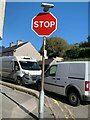
Stop sign at the junction of Snowdon Street and Bangor Street, Y Felinheli
Image: © Meirion
Taken: 13 Oct 2022
0.04 miles
4
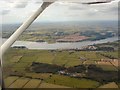
Looking across to Anglesey
In the foreground is the A487 Y Felinheli bypass and then across the Menai Straits stretch the island of Anglesey.
Image: © Gerald England
Taken: 28 Aug 1998
0.05 miles
5
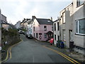
Junction of Snowdon Street and Augusta Place
In the centre of the older part of Y Felinheli.
Image: © Christine Johnstone
Taken: 24 Nov 2018
0.06 miles
6
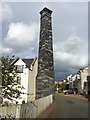
Old Industrial Chimney on South Dock, Y Felinheli
A distinctive chimney built of large slate blocks. The chimney is the only surviving evidence of the industrial buildings which once stood on the old south dock in Y Felinheli (Port Dinorwic). The area has now been redeveloped as high-end housing. The street the chimney now stands on is called Hen Gei Llechi (Old Slate Quay).
Image: © Meirion
Taken: 3 Nov 2011
0.06 miles
7
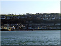
Felinheli from Moel y Don
View of Felinheli from Moel y Don looking across the Menai Straits
Image: © Nigel Williams
Taken: 28 Jan 2006
0.06 miles
8
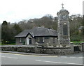
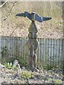
Llanfairisgaer Church House and War Memorial clock
At Pondinorwig
Image: © Eirian Evans
Taken: 11 Apr 2008
0.06 miles
9
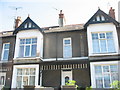
Houses in Bangor Street, Y Felinheli
These terraced houses date from the Victorian period when Y Felinheli (then also known as Port Dinorwic) was an important slate exporting port. Prior to the construction of the Felinheli by-pass, Bangor Street and Caernarfon Street,(its western continuation), were part of the busy A487(T) road.
Image: © Eric Jones
Taken: 9 Sep 2006
0.06 miles
10
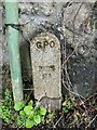
GPO cable marker on Caernarfon Road, Y Felinheli
http://www.ringbell.co.uk/nostalgia/AAT.htm
Image: © Meirion
Taken: 13 Oct 2022
0.07 miles