IMAGES TAKEN NEAR TO
Nant Peris, CAERNARFON, LL55 4UE
Introduction
This page details the photographs taken nearby to LL55 4UE by members of the Geograph project.
The Geograph project started in 2005 with the aim of publishing, organising and preserving representative images for every square kilometre of Great Britain, Ireland and the Isle of Man.

There are currently over 7.5m images from over14,400 individuals and you can help contribute to the project by visiting https://www.geograph.org.uk
Image Map
Images are licensed for reuse under creativecommons.org/licenses/by-sa/2.0
Notes
- Clicking on the map will re-center to the selected point.
- The higher the marker number, the further away the image location is from the centre of the postcode.
Image Listing (50 Images Found)
Images are licensed for reuse under creativecommons.org/licenses/by-sa/2.0
Image
Details
Distance
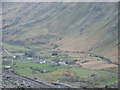
5
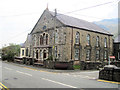
Nant Peris
The village of Nant Peris sits between Llanberis and Capel Curig on the A4086, sheltering in the foothills of Mount Snowdon.
Image: © David Dixon
Taken: 16 Feb 2022
0.02 miles
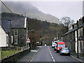
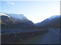
6
Approaching the A4086 on the Fron Road, Nant Peris
Snowdon's Llanberis ridge forms the background.
Image: © Eric Jones
Taken: 22 Feb 1998
0.03 miles
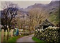
7
Nant Peris
Cottages in the hamlet of Nant Peris in the Pass of Llanberis
Image: © Dot Potter
Taken: 17 Apr 2006
0.03 miles
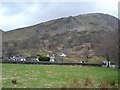
8
Road into Llanberis Pass
View from the end of Llyn Peris looking into the pass with Glyder Fawr in the background.
Image: © Albie Niedojadlo
Taken: 19 Dec 2004
0.03 miles
9
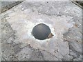
OSBM bolt benchmark on Pont yr Afr, Nant Peris
This Ordnance Survey benchmark is located on the NE parapet of Pont yr Afr in Nant Peris and it is shown in the current Ordnance Survey database at a height of 112.5794m above the Newlyn datum.
Image: © Meirion
Taken: 11 Jun 2012
0.04 miles