IMAGES TAKEN NEAR TO
Maes Derlwyn, CAERNARFON, LL55 4TW
Introduction
This page details the photographs taken nearby to Maes Derlwyn, LL55 4TW by members of the Geograph project.
The Geograph project started in 2005 with the aim of publishing, organising and preserving representative images for every square kilometre of Great Britain, Ireland and the Isle of Man.

There are currently over 7.5m images from over14,400 individuals and you can help contribute to the project by visiting https://www.geograph.org.uk
Image Map (Loading...)


Getting Data...Please wait
Leaflet Map data © OpenStreetMap
Images are licensed for reuse under creativecommons.org/licenses/by-sa/2.0
Notes
- Clicking on the map will re-center to the selected point.
- The higher the marker number, the further away the image location is from the centre of the postcode.
Image Listing (175 Images Found)
Images are licensed for reuse under creativecommons.org/licenses/by-sa/2.0
Image
Details
Distance
2
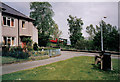
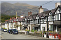
Maes Derlwyn
Leading onto Maes Fictoria. A walk along this road is a necessary part of the route up Snowdon.
Image: © Bill Boaden
Taken: 6 Sep 2017
0.01 miles
3
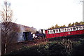
A Snowdon bound train leaves Llanberis
Image: © nick macneill
Taken: 6 Apr 2001
0.02 miles
4
Snowdon Mountain Railway
The Snowdon narrow gauge railway begins its long journey to the top.
Image: © Tony Bacon
Taken: Unknown
0.02 miles
5
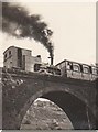
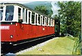
Snowdon Railway
A steam train on the Snowdon Mountain Railway crossing the viaduct in Llanberis, July, 1955.
Image: © David Chatterton
Taken: Unknown
0.03 miles
6
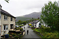
Start of the Llanberis Path
The Llanberis Path is the longest and most gradual route to the summit of Snowdon. It is the most popular path amongst leisurely walkers as it is generally considered to be the easiest walk in mild weather although, in winter, the higher slopes can become very dangerous. The section above Clogwyn station has long been called the "Killer Convex"; in icy conditions, this convex slope can send unwary walkers over the cliffs of Clogwyn Du'r Arddu. Four people died there in February 2009 (http://news.bbc.co.uk/1/hi/wales/8177483.stm BBC News).
Image: © David Dixon
Taken: 16 Feb 2022
0.03 miles
7
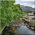
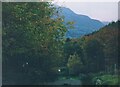
River flowing through Llanberis
Afon Hwch or Afon Arddu
OS maps does not give name after they meet
Image: © Jim Smillie
Taken: 12 May 2022
0.03 miles
9
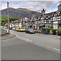
Vaynol Cottages and York Terrace
Edwardian terraces at the start of the Llanberis Path up Snowdon. The plaque on Vaynol Cottages (nearer the camera) shows a building date of 1906.
Image: © Ian Capper
Taken: 24 Sep 2013
0.04 miles
10
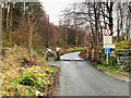
Approaching the cattle grid at the bottom of the Hafoty Newydd Road
This section of road cutting through Coed Victoria is used by thousands of walkers making for the start of the Llanberis Path to the summit of Snowdon. The slate tips of Dinorwig Quarry fill the background. In the late 2000s Coed Victoria were harvested.
Image: © Eric Jones
Taken: Unknown
0.05 miles