IMAGES TAKEN NEAR TO
Llanberis, CAERNARFON, LL55 4SS
Introduction
This page details the photographs taken nearby to LL55 4SS by members of the Geograph project.
The Geograph project started in 2005 with the aim of publishing, organising and preserving representative images for every square kilometre of Great Britain, Ireland and the Isle of Man.

There are currently over 7.5m images from over14,400 individuals and you can help contribute to the project by visiting https://www.geograph.org.uk
Image Map (Loading...)


Getting Data...Please wait
Leaflet Map data © OpenStreetMap
Images are licensed for reuse under creativecommons.org/licenses/by-sa/2.0
Notes
- Clicking on the map will re-center to the selected point.
- The higher the marker number, the further away the image location is from the centre of the postcode.
Image Listing (23 Images Found)
Images are licensed for reuse under creativecommons.org/licenses/by-sa/2.0
Image
Details
Distance
1
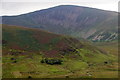
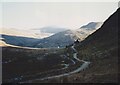
Tynyraelgerth and Moel Eilio from the Snowdon Mountain Railway
Image: © Mike Pennington
Taken: 27 Aug 2019
0.01 miles
2
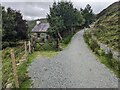
The path past Ty'n-yr-Aelgerth
A descriptive name (the house in the...), but I don't know what it means.
Image: © David Medcalf
Taken: 27 Aug 2023
0.02 miles
3
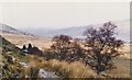
Descending the Maesgwm Path in the direction of Tyn-yr-aelgerth
Ty'n-yr-aelgerth means "croft on the brow of the hill"
Image: © Eric Jones
Taken: 8 Mar 1998
0.05 miles
4
Ty'n yr Aelgerth
One of the few inhabited houses left in Cwm Brwynog, a valley which has suffered wholesale depopulation since the 1950s. The green lane leads up over Maesgwm to the Snowdon Ranger YH on the shores of Llyn Gwynant. The mountain in the background, with the landslip scar, is Moel Cynghorion.
Image: © Eric Jones
Taken: 8 Apr 2006
0.05 miles
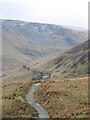
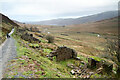
5
The Maesgwm Track contouring along the slopes of the Aelgerth
The valley on the left is that of Afon Arddu, which has its source in Cwm Du'r Arddu high on Snowdon. The sunlit tree at the foot of Moel Cynghorion is at Helfa Fawr, which in 2000 was still a roofless ruin.
Image: © Eric Jones
Taken: Unknown
0.08 miles
6
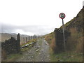
No Motor Vehicles
The track approaching Ty'n yr Aelgerth.
Image: © Eric Jones
Taken: 8 Apr 2006
0.08 miles

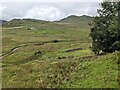
8

Bridleway above Ty'n-yr-aelgerth
Ty'n-yr-aelgerth cottage stands in the clump of trees in the middle distance. Its name means 'croft on the brow of the hill'.
Image: © Eric Jones
Taken: 21 Sep 2008
0.11 miles
9
Ruined buildings below the Maesgwm bridleway
The bridleway from Snowdon Ranger station, over Bwlch Maesgwm and on down towards Llanberis is the subject of ongoing work, presumably to "smart bridleway" standard, with traffic lights and lane closures to regulate the high speed traffic which nowadays permeates Snowdonia. Perhaps not in this weather, though the small dumper truck being driven backwards a lot faster than we can walk is just one a bevvy of works vehicles working on drains, retaining walls and compacting the surface of the track and parking areas just off it. Two National Park Warden Landrovers were also prominent in their presence a long way from anything resembling a public road - maybe it was the only place they could find to park for free. The ruined buildings don't seem to be being converted into part of the Llanberis urban sprawl (yet).
Image: © Andy Waddington
Taken: 11 Nov 2021
0.11 miles
10
Looking down on the Rifle Range (dis)
How long since bullets were fired here? It was certainly a safe location for it.
Image: © David Medcalf
Taken: 27 Aug 2023
0.12 miles