IMAGES TAKEN NEAR TO
Ceunant, CAERNARFON, LL55 4RT
Introduction
This page details the photographs taken nearby to LL55 4RT by members of the Geograph project.
The Geograph project started in 2005 with the aim of publishing, organising and preserving representative images for every square kilometre of Great Britain, Ireland and the Isle of Man.

There are currently over 7.5m images from over14,400 individuals and you can help contribute to the project by visiting https://www.geograph.org.uk
Image Map (Loading...)


Getting Data...Please wait
Leaflet Map data © OpenStreetMap
Images are licensed for reuse under creativecommons.org/licenses/by-sa/2.0
Notes
- Clicking on the map will re-center to the selected point.
- The higher the marker number, the further away the image location is from the centre of the postcode.
Image Listing (4 Images Found)
Images are licensed for reuse under creativecommons.org/licenses/by-sa/2.0
Image
Details
Distance
1
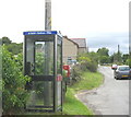
Bocs Teliffon /Telephone Box, Tan-y-coed
The BT telephone box in the linear village of Tan-y-Coed (meaning 'Below the Woods') bears the Welsh inscription 'e-bost - testun - ffon' i.e. e-mail -text -phone. The 'e' in 'e-bost' is pronouned as 'e' in eskimo.
Image: © Eric Jones
Taken: 11 Aug 2006
0.06 miles

4
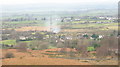
Boxing Day gorse burning at Tan-y-coed
Judging by the number of fires visible from the hillside, the burning of gorse as a Boxing Day activity retains its popularity.
Image: © Eric Jones
Taken: 26 Dec 2006
0.16 miles