IMAGES TAKEN NEAR TO
Pentre Helen, CAERNARFON, LL55 3LW
Introduction
This page details the photographs taken nearby to Pentre Helen, LL55 3LW by members of the Geograph project.
The Geograph project started in 2005 with the aim of publishing, organising and preserving representative images for every square kilometre of Great Britain, Ireland and the Isle of Man.

There are currently over 7.5m images from over14,400 individuals and you can help contribute to the project by visiting https://www.geograph.org.uk
Image Map
Images are licensed for reuse under creativecommons.org/licenses/by-sa/2.0
Notes
- Clicking on the map will re-center to the selected point.
- The higher the marker number, the further away the image location is from the centre of the postcode.
Image Listing (70 Images Found)
Images are licensed for reuse under creativecommons.org/licenses/by-sa/2.0
Image
Details
Distance
1
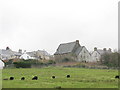
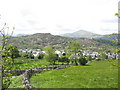
Pentre Helen Housing Estate
This large housing estate was built in the late 1930s, effectively linking Deiniolen and Clwt y Bont into one village. Built on an exposed hillside, and painted bright yellow then, the estate is reputed to have had a special mention from Hamburg Radio, when Lord Haw Haw warned that "Yellow Village" in North Wales was on the Luftwaffe's target list.
Image: © Eric Jones
Taken: 21 Sep 2006
0.03 miles
2
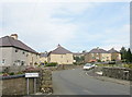
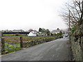
Looking across Ffridd Gel towards the Pentre Helen Estate
Ffridd Gel, an area of rough grazing, was where touring circuses used to set up camp in the 1950s and early 60s. The stone wall marks the line of the 1824 Dinorwig Quarry tramway which preceded the Padarn Railway. The Pentre Helen Council estate beyond was built shortly before World War II and physically united the then separate villages of Deiniolen and Clwt y bont.
Image: © Eric Jones
Taken: 17 Feb 2007
0.04 miles
3
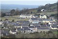
Deiniolen o Gallt-y-Foel / Deinolen from Gallt-y-Foel
Image: © Ceri Thomas
Taken: 3 Nov 2019
0.07 miles
6
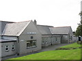
Ysgol Gwaen Gynfi, Deiniolen
My old Alma Mater. Built in 1927 it has 170 pupils and 7 teachers and its catchment area includes the villages of Deiniolen and Dinorwig and their surrounding rural areas.At 11 years of age pupils transfer to Ysgol Brynrefail, at Llanrug, 3 miles away. Image
Image: © Eric Jones
Taken: 21 Sep 2006
0.10 miles
7
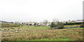
The Line of the 1824 Dinorwig Tramway
The tramway having followed the axial street of Clwt y Bont, crosses the Deiniolen-Caernarfon road and enters open country across Ffridd Gel.
Image: © Eric Jones
Taken: 21 Sep 2006
0.10 miles
8
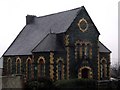
Libanys Chapel in Deiniolen
Libanys Chapel in the village of Deiniolen dates back to 1877
Image: © Nigel Williams
Taken: 12 Feb 2006
0.12 miles
9
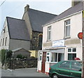
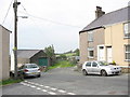
Post Office and Shop, Clwt y Bont
This sub-post office and newsagents is the only shop left in Clwt y Bont. Next door is Libanys (sic) Chapel. Libanus, and its sister chapel, Sardis, at Dinorwig - literally the highest chapel in England and Wales - come under the wing of Penuel Chapel, Bangor Image Penuel has a Welsh language site which deals with Libanus and Sardis under the title' Eglwysi eraill yr Ofalaeth' (other churches within the pastorate). http://www.penuelbangor.co.uk
Image: © Eric Jones
Taken: 21 Sep 2006
0.12 miles