IMAGES TAKEN NEAR TO
Pentre Helen, CAERNARFON, LL55 3LN
Introduction
This page details the photographs taken nearby to Pentre Helen, LL55 3LN by members of the Geograph project.
The Geograph project started in 2005 with the aim of publishing, organising and preserving representative images for every square kilometre of Great Britain, Ireland and the Isle of Man.

There are currently over 7.5m images from over14,400 individuals and you can help contribute to the project by visiting https://www.geograph.org.uk
Image Map (Loading...)


Getting Data...Please wait
Leaflet Map data © OpenStreetMap
Images are licensed for reuse under creativecommons.org/licenses/by-sa/2.0
Notes
- Clicking on the map will re-center to the selected point.
- The higher the marker number, the further away the image location is from the centre of the postcode.
Image Listing (73 Images Found)
Images are licensed for reuse under creativecommons.org/licenses/by-sa/2.0
Image
Details
Distance
2
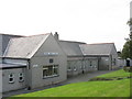
Ysgol Gwaen Gynfi, Deiniolen
My old Alma Mater. Built in 1927 it has 170 pupils and 7 teachers and its catchment area includes the villages of Deiniolen and Dinorwig and their surrounding rural areas.At 11 years of age pupils transfer to Ysgol Brynrefail, at Llanrug, 3 miles away. Image
Image: © Eric Jones
Taken: 21 Sep 2006
0.04 miles
3
Ysgol Gwaun Gynfi, Deiniolen
My old alma mater
Image: © Eric Jones
Taken: 19 May 2007
0.06 miles
4
Ysgol Gwaen Gynfi, Deiniolen
This was my first Alma Mater. In those days it was known as Ysgol Ganol Deiniolen Central School. Until the 1960s the Anglicans had their own school near Llandinorwig Church. I recall one memorable dinner hour when practically the whole of the school marched up the hill to lay siege to the Anglican school over some perceived or imagined insult. This was a continuation of a tradition which had gone on for generations.
Image
Image: © Eric Jones
Taken: 23 Jan 2011
0.07 miles
5
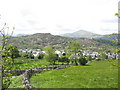
Deiniolen o Gallt-y-Foel / Deinolen from Gallt-y-Foel
Image: © Ceri Thomas
Taken: 3 Nov 2019
0.08 miles
6
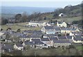
Looking across Ffridd Gel towards the Pentre Helen Estate
Ffridd Gel, an area of rough grazing, was where touring circuses used to set up camp in the 1950s and early 60s. The stone wall marks the line of the 1824 Dinorwig Quarry tramway which preceded the Padarn Railway. The Pentre Helen Council estate beyond was built shortly before World War II and physically united the then separate villages of Deiniolen and Clwt y bont.
Image: © Eric Jones
Taken: 17 Feb 2007
0.08 miles
7
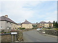
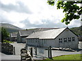
Pentre Helen Housing Estate
This large housing estate was built in the late 1930s, effectively linking Deiniolen and Clwt y Bont into one village. Built on an exposed hillside, and painted bright yellow then, the estate is reputed to have had a special mention from Hamburg Radio, when Lord Haw Haw warned that "Yellow Village" in North Wales was on the Luftwaffe's target list.
Image: © Eric Jones
Taken: 21 Sep 2006
0.09 miles
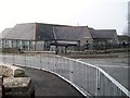
9
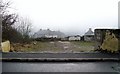
The cleared site of the old Hanroy Cinema
The site has been cleared for redevelopment. After its closure the old cinema had been converted into a glazier's workshop. That company has now moved its base to Caernarfon.
Image
Image: © Eric Jones
Taken: 23 Jan 2011
0.10 miles
10
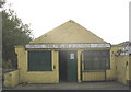
The Old Hanroy Cinema, Deiniolen
Now a glaziers' workshop, this building was the village cinema between 1952 and the coming of television (snowy pictures from the Holme Moss transmitter) around 1959. The roof was of corrugated iron and a shower of rain would effectively drown out the film, not that it was easy to hear much over the riot that would be going on inside. I spent hours here watching such films as 'Abbot and Costello Meet the Ghosts' and 'The Mario Lanza Story'.
Image: © Eric Jones
Taken: 21 Sep 2006
0.10 miles