IMAGES TAKEN NEAR TO
North Road, CAERNARFON, LL55 3HY
Introduction
This page details the photographs taken nearby to North Road, LL55 3HY by members of the Geograph project.
The Geograph project started in 2005 with the aim of publishing, organising and preserving representative images for every square kilometre of Great Britain, Ireland and the Isle of Man.

There are currently over 7.5m images from over14,400 individuals and you can help contribute to the project by visiting https://www.geograph.org.uk
Image Map (Loading...)


Getting Data...Please wait
Leaflet Map data © OpenStreetMap
Images are licensed for reuse under creativecommons.org/licenses/by-sa/2.0
Notes
- Clicking on the map will re-center to the selected point.
- The higher the marker number, the further away the image location is from the centre of the postcode.
Image Listing (86 Images Found)
Images are licensed for reuse under creativecommons.org/licenses/by-sa/2.0
Image
Details
Distance
1
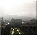
Approaching Porth Gogladd from the direction of Caeau Uchaf
The correct name of the street is Porth Gogledd, but this changes in the North West Wales dialect ( the "Wyndodeg") into Porth Gogladd. The large chapel on the right is Capel Ebenezer, but commonly referred to as "Capal Eban".
Image: © Eric Jones
Taken: 23 Jan 2011
0.01 miles
2
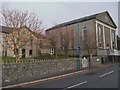
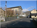
A rear view of Ebenezer Chapel and vestry
Locally, this Congregational chapel built in 1823, is known as Capal Eban. Ebenezer became the name of the village which grew around it. It was only in 1922 that the name Deiniolen was coined. An older local name for the village, and one still very much in use, is Llanbabo, as many of the first inhabitants originated from Llanbabo in Anglesey. Deiniolen people are often referred to as "Llanbabs".
Image
Image: © Eric Jones
Taken: 5 Apr 2008
0.03 miles
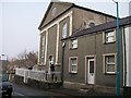
3
Capal Eban
Known officially as Capel Ebenezer/Ebeneser, this former congregational chapel, now an united church, is known in the village simply as Capal Eban. The photo shows both the vestry (on the left) and the main chapel (on the right). Until the adoption of the name Deiniolen in 1922 the village was also known officially as Ebenezer, though colloquially the name Llanbabo was in use.
Image: © Eric Jones
Taken: 23 Jan 2011
0.03 miles
4
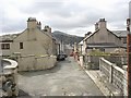
Porth y Gogledd/North Road
This short backstreet leads north from the High Street. This is where VE Day and Coronation Day tea parties for the children of the High Street and its side streets were held.
Image: © Eric Jones
Taken: 5 Apr 2008
0.03 miles
5

Siop Ffowc at Chester House, Stryd Fawr, Deiniolen
This photograph, taken in the eariy 1920s by an itinerant commercial photographer shows Foulk Williams, Bryn Gro in the door of his grocery store in the slate quarrying village of Deiniolen. Foulk a quarryman at Dinorwig Quarry had been badly injured fighting with the 10th Batt RWF in the Battle for Delville Wood in June 1916 and was physically incapable of returning to the quarry. He and his wife, Jennie, ran the shop until his death in 1965
Image: © Eric Jones
Taken: 1 Jan 1921
0.03 miles
6
Deiniolen
The main road going through Deiniolen, with Ebenezer chapel on the left. The village was originally called Ebenezer.
Image: © Eirian Evans
Taken: 23 Apr 2008
0.03 miles
7
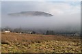
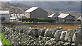
Fields behind the High Street, Deiniolen
Image: © Eric Jones
Taken: 23 Jan 2011
0.03 miles
8
Approaching Deiniolen from the direction of Caeau Uchaf
Image: © Eric Jones
Taken: 23 Jan 2011
0.03 miles
9
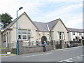
Yr Hen Lyfrgell - The Old Library
This library was built in 1913 with a grant from the Carneige Fund. The left hand of the building was used as a library and the right hand as a snooker hall. The village war memorial stands outside the building.
The library is now housed at the community centre in the High Street.
Image: © Eric Jones
Taken: 21 Sep 2006
0.03 miles
10
The western end of Stryd Fawr/High Street, Deiniolen
Capel Ebenezer (Capal Eban) is the large building on the right.
Image: © Eric Jones
Taken: 23 Jan 2011
0.03 miles