IMAGES TAKEN NEAR TO
Pontrug, CAERNARFON, LL55 1UA
Introduction
This page details the photographs taken nearby to LL55 1UA by members of the Geograph project.
The Geograph project started in 2005 with the aim of publishing, organising and preserving representative images for every square kilometre of Great Britain, Ireland and the Isle of Man.

There are currently over 7.5m images from over14,400 individuals and you can help contribute to the project by visiting https://www.geograph.org.uk
Image Map
Images are licensed for reuse under creativecommons.org/licenses/by-sa/2.0
Notes
- Clicking on the map will re-center to the selected point.
- The higher the marker number, the further away the image location is from the centre of the postcode.
Image Listing (10 Images Found)
Images are licensed for reuse under creativecommons.org/licenses/by-sa/2.0
Image
Details
Distance
1
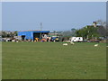
Lon Glai
A farm just south-west of Bethel.
Image: © Eirian Evans
Taken: 24 Apr 2009
0.07 miles
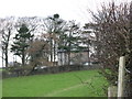
2
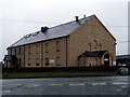
The old Nazareth Chapel
This converted chapel was originally built in 1881
Image: © Nigel Williams
Taken: 12 Feb 2006
0.11 miles
3
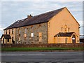
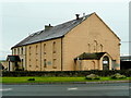
Nazareth Chapel Pontrug
A converted chapel, which was in the late seventies and eighties the base for Barton Engineering. Barton Engineering and Spondon frames produced the Sparton racing motorcycle, one of which became famous in the film 'Silver Dream Racer' starring David Essex.
Image: © Chris Andrews
Taken: 5 Aug 2018
0.12 miles
4
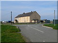
Capel Nazareth, Pont-rug
Now used for business purposes.
Image: © Jonathan Billinger
Taken: 6 May 2009
0.12 miles
5
Capel Nazareth, Pont-Rug
Former chapel and attached chapel house at Pont-Rug, east of Caernarfon.
Image: © Eirian Evans
Taken: 24 Apr 2009
0.12 miles
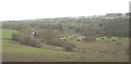
6
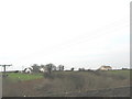
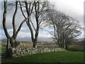
View across the incised Seiont valley to Lon Glai
The building on the right is the old Capel Nazareth and Chapel House.
Image: © Eric Jones
Taken: 25 Dec 2006
0.17 miles
7
View over the Seiont valley
Looking towards Moel Eilio shrouded in cloud.
Image: © Jonathan Billinger
Taken: 6 May 2009
0.19 miles
8
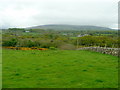
Seiont Valley above Pont-rug
The ditch through the boggy area parallel with the bottom of the slope was a leat carrying water for powering the now disappeared Pont-rug slate works which produced writing slates for schools.
Image: © Eric Jones
Taken: 25 Dec 2006
0.23 miles
9
Approaching Erw-Pwll-y-Glo
This is a gentleman's residence with an intriguing name. Erw-Pwll-y-Glo translates as Coal Pit Acre. The nearest coal measures however are in the Malltraeth area of Anglesey. The meaning as in the village name of Cwm y Glo, 4 miles to the south, could be to do with the production of charcoal.
Image
Image: © Eric Jones
Taken: 25 Dec 2006
0.23 miles