IMAGES TAKEN NEAR TO
Rhostryfan, CAERNARFON, LL54 7NG
Introduction
This page details the photographs taken nearby to LL54 7NG by members of the Geograph project.
The Geograph project started in 2005 with the aim of publishing, organising and preserving representative images for every square kilometre of Great Britain, Ireland and the Isle of Man.

There are currently over 7.5m images from over14,400 individuals and you can help contribute to the project by visiting https://www.geograph.org.uk
Image Map (Loading...)


Getting Data...Please wait
Leaflet Map data © OpenStreetMap
Images are licensed for reuse under creativecommons.org/licenses/by-sa/2.0
Notes
- Clicking on the map will re-center to the selected point.
- The higher the marker number, the further away the image location is from the centre of the postcode.
Image Listing (9 Images Found)
Images are licensed for reuse under creativecommons.org/licenses/by-sa/2.0
Image
Details
Distance
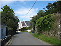
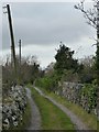
1
Narrow lane linking Rhos Isaf and Rhostryfan
Image: © Eric Jones
Taken: 15 Jul 2008
0.06 miles
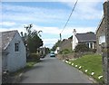
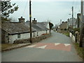
2
Bridleway entrance, Rhos Isaf
Just south of Penlan Isaf. Also the entrance to Pencaenewydd.
Image: © Christine Johnstone
Taken: 17 Nov 2013
0.07 miles
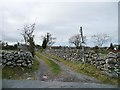
4
Public bridleway, south of Penlan Isaf
Running south-west to a six-way track and path junction south-east of Cae ciprys.
Image: © Christine Johnstone
Taken: 17 Nov 2013
0.07 miles
5
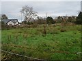
Rough pasture in the centre of Rhos Isaf
'Rhos Isaf' is Welsh for Low Moor. This area is a broad stream-filled hillside.
Image: © Christine Johnstone
Taken: 17 Nov 2013
0.09 miles
6
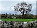
Tree on a field boundary, Rhos Isaf
Losing its leaves and exposing the ivy.
Image: © Christine Johnstone
Taken: 17 Nov 2013
0.09 miles
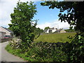
8
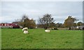
Sheep pasture, Rhos Isaf
Junst north of Penlan Isaf.
Image: © Christine Johnstone
Taken: 17 Nov 2013
0.10 miles