
IMAGES TAKEN NEAR TO
Bro Wyled, CAERNARFON, LL54 7LP
Introduction
This page details the photographs taken nearby to Bro Wyled, LL54 7LP by members of the Geograph project.
The Geograph project started in 2005 with the aim of publishing, organising and preserving representative images for every square kilometre of Great Britain, Ireland and the Isle of Man.

There are currently over 7.5m images from over14,400 individuals and you can help contribute to the project by visiting https://www.geograph.org.uk
Image Map
Images are licensed for reuse under creativecommons.org/licenses/by-sa/2.0
Notes
- Clicking on the map will re-center to the selected point.
- The higher the marker number, the further away the image location is from the centre of the postcode.
Image Listing (29 Images Found)
Images are licensed for reuse under creativecommons.org/licenses/by-sa/2.0
Image
Details
Distance
1

Rhostryfan Primary School
An immaculate slate roof and a magnificent view over Caernarfon Bay make the village school special.
Image: © Jonathan Wilkins
Taken: 24 Feb 2017
0.05 miles
2

Track to Gaerwen
The track leading uphill to Gaerwen carries a public footpath. Gorse in the field margins is putting on a good show in the late February sunshine.
Image: © Jonathan Wilkins
Taken: 24 Feb 2017
0.05 miles
3
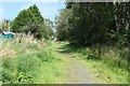
Bryngwyn branch heading north to the site of Rhostryfan Station
With a cat for scale. The Bryngwyn [narrow gauge railway] branch was built to carry slate from the quarries to the coast. The line opened in 1877 and closed in 1937. It is now the Cangen Bryngwyn Branch slate railway trail. You can follow the route of the railway from Tryfan Junction, through Rhostryfan and Bryngwyn to the site of the drumhead at the top of the incline. The trail was created by Cyngor Cymuned Llanwnda / Llanwnda Community Council.
Image: © Christine Johnstone
Taken: 20 Aug 2019
0.05 miles
5
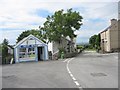
Y Groeslon - The crossroads at Rhostryfan
Image: © Eric Jones
Taken: 15 Jul 2008
0.06 miles
6
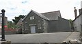
Capel Horeb, Rhostryfan
Capel Horeb, a Calvinistic Methodist chapel, was built in 1866.
Image: © Eric Jones
Taken: 15 Jul 2008
0.06 miles
7
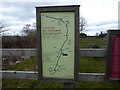
Llwybr Llechi information board
Near the site of the Rhosgadfan station on the Bryngwyn Branch of the North Wales Narrow Gauge Railway.
Image: © Eirian Evans
Taken: 29 Mar 2018
0.07 miles
8

Railway bridge
The track of the Bryngwyn branch of the North Wales Narrow Gauge Railway. The crown of the arch executed in brick is a surprising feature, and the cosmopolitan nature of the large squared blocks of the walls is remarkable. The incline in the modern path between the stream crossing at the camera location and the main village road is a modern feature which results from filling the railway cutting beneath another similar bridge.
Image: © Jonathan Wilkins
Taken: 24 Feb 2017
0.07 miles
9
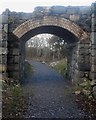
Pont Droed Dros Gangen Bryngwyn / Footbridge Over The Bryngwyn Branch
This bridge looks as though it was built to carry light traffic, but is shown as being only a footbridge on old Ordnance Survey maps.
Image: © Ceri Thomas
Taken: 19 Jan 2014
0.07 miles
10
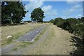
The site of Rhostryfan station, Bryngwyn branch
Recreated as a picnic area. The Bryngwyn [narrow gauge railway] branch was built to carry slate from the quarries to the coast. The line opened in 1877 and closed in 1937. It is now the Cangen Bryngwyn Branch slate railway trail. You can follow the route of the railway from Tryfan Junction, through Rhostryfan and Bryngwyn to the site of the drumhead at the top of the incline. The trail was created by Cyngor Cymuned Llanwnda / Llanwnda Community Council.
Image: © Christine Johnstone
Taken: 20 Aug 2019
0.07 miles