IMAGES TAKEN NEAR TO
Carmel, CAERNARFON, LL54 7AN
Introduction
This page details the photographs taken nearby to LL54 7AN by members of the Geograph project.
The Geograph project started in 2005 with the aim of publishing, organising and preserving representative images for every square kilometre of Great Britain, Ireland and the Isle of Man.

There are currently over 7.5m images from over14,400 individuals and you can help contribute to the project by visiting https://www.geograph.org.uk
Image Map
Images are licensed for reuse under creativecommons.org/licenses/by-sa/2.0
Notes
- Clicking on the map will re-center to the selected point.
- The higher the marker number, the further away the image location is from the centre of the postcode.
Image Listing (31 Images Found)
Images are licensed for reuse under creativecommons.org/licenses/by-sa/2.0
Image
Details
Distance
1
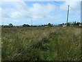
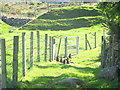
Public footpath heading west from Capel y Bryn
Across open access moorland.
Image: © Christine Johnstone
Taken: 19 Aug 2019
0.04 miles
2
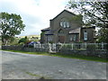
Capel y Bryn, from the west
Chapel built in 1906, now converted into a house.
Image: © Christine Johnstone
Taken: 19 Aug 2019
0.05 miles
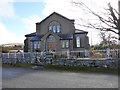
3
Capel y Bryn, from the east
Chapel built in 1906, now converted to a house.
Image: © Christine Johnstone
Taken: 19 Aug 2019
0.05 miles
5
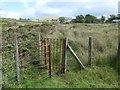
Public footpath heading east to Capel y Bryn
Entering open access moorland through a kissing gate.
Image: © Christine Johnstone
Taken: 19 Aug 2019
0.06 miles
7
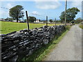
Slate drystone wall, west of Glandwr
A good example of how slate splits into long thin blocks - hence its use for roofs.
Image: © Christine Johnstone
Taken: 19 Aug 2019
0.08 miles
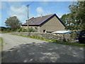
8
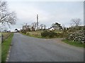
A road to Rhosgadfan
The hillside between Carmel and Rhos Isaf is full of scattered houses, tiny fields, footpaths and wiggly roads.
Image: © Christine Johnstone
Taken: 17 Nov 2013
0.09 miles
9
![Dam of a former reservoir near Bryngwyn station [land side]](https://s0.geograph.org.uk/geophotos/06/24/94/6249420_d08192a9_120x120.jpg)
Dam of a former reservoir near Bryngwyn station [land side]
The reservoir was built between 1899 and 1913 and was still present in 1948. It held the water of a spring-fed tributary of Afon Llifon.
Image: © Christine Johnstone
Taken: 19 Aug 2019
0.09 miles
10
![Dam of a former reservoir near Bryngwyn station [water side]](https://s0.geograph.org.uk/geophotos/06/24/94/6249424_20bad759_120x120.jpg)
Dam of a former reservoir near Bryngwyn station [water side]
The reservoir was built between 1899 and 1913 and was still present in 1948. It held the water of a spring-fed tributary of Afon Llifon.
Image: © Christine Johnstone
Taken: 19 Aug 2019
0.09 miles