IMAGES TAKEN NEAR TO
Rhwng Llwyni Terrace, CAERNARFON, LL54 6RH
Introduction
This page details the photographs taken nearby to Rhwng Llwyni Terrace, LL54 6RH by members of the Geograph project.
The Geograph project started in 2005 with the aim of publishing, organising and preserving representative images for every square kilometre of Great Britain, Ireland and the Isle of Man.

There are currently over 7.5m images from over14,400 individuals and you can help contribute to the project by visiting https://www.geograph.org.uk
Image Map
Images are licensed for reuse under creativecommons.org/licenses/by-sa/2.0
Notes
- Clicking on the map will re-center to the selected point.
- The higher the marker number, the further away the image location is from the centre of the postcode.
Image Listing (39 Images Found)
Images are licensed for reuse under creativecommons.org/licenses/by-sa/2.0
Image
Details
Distance
1
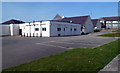
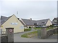
Ysgol Dyffryn Nantlle, Penygroes
The comprehensive school (for pupils aged 11 to 18) occupies much of the west side of Ffordd y Brenin.
Image: © Jaggery
Taken: 24 Mar 2012
0.03 miles
2
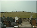
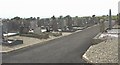
Penygroes Cemetery
Looking west towards the Trig Point of Tre Ddafydd [David's town :-) ] visible just right of centre.
Image: © David Medcalf
Taken: 23 Mar 2006
0.04 miles
3
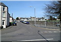
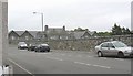
Ffordd y Brenin, Penygroes
A view north from the B4418. Maps show Kings Road as well as the Welsh name Ffordd y Brenin.
The street name sign on the right shows only Ffordd y Brenin.
Image: © Jaggery
Taken: 24 Mar 2012
0.08 miles
4
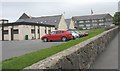
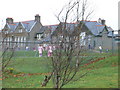
Ysgol Dyffryn Nantlle
This is a 11-18 comprehensive school serving the Nantlle Valley (Dyffryn Nantlle).
www.ydn.gwynedd.sch.uk/
Image: © Eric Jones
Taken: 15 Jul 2008
0.08 miles
5

Trig point in field at Penygroes
Penygroes is a village of North Wales close to the Snowdonia National Park and now by-passed by the A487. The pillar is in a small field with buildings of the village close by on several sides. The hill are to the north and are The Rivals.
Image: © Trevor Littlewood
Taken: 11 Sep 2005
0.09 miles
6
New block at Ysgol Dyffryn Nantlle
www.ydn.gwynedd.sch.uk/
Image: © Eric Jones
Taken: 15 Jul 2008
0.10 miles
8
Ysgol Gynradd Bro Lleu Primary School
This school occupies the building once used by the Penygroes Intermediate School. Bro Lleu is a 3-11 years old community school.
Image: © Eric Jones
Taken: 15 Jul 2008
0.12 miles
9
Penygroes Junior School
Taken on 14th November, Children in Need Day, when the pupils could come to school in nightclothes.
Image: © Eirian Evans
Taken: 14 Nov 2008
0.12 miles
10
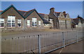
Primary School, Penygroes
Ysgol Bro Lleu is the village's primary school, located on the east side of Ffordd y Brenin,
opposite the village's comprehensive school Ysgol Dyffryn Nantlle. http://www.geograph.org.uk/photo/3460531
Image: © Jaggery
Taken: 24 Mar 2012
0.14 miles