IMAGES TAKEN NEAR TO
Caernarfon Road, CAERNARFON, LL54 6PP
Introduction
This page details the photographs taken nearby to Caernarfon Road, LL54 6PP by members of the Geograph project.
The Geograph project started in 2005 with the aim of publishing, organising and preserving representative images for every square kilometre of Great Britain, Ireland and the Isle of Man.

There are currently over 7.5m images from over14,400 individuals and you can help contribute to the project by visiting https://www.geograph.org.uk
Image Map
Images are licensed for reuse under creativecommons.org/licenses/by-sa/2.0
Notes
- Clicking on the map will re-center to the selected point.
- The higher the marker number, the further away the image location is from the centre of the postcode.
Image Listing (24 Images Found)
Images are licensed for reuse under creativecommons.org/licenses/by-sa/2.0
Image
Details
Distance
1
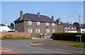
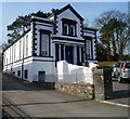
Bro Llwyndu, Penygroes
Bro Llwyndu is a cul-de-sac in the north of the village.
Image: © Jaggery
Taken: 24 Mar 2012
0.05 miles
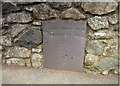
2
Milestone On Former A487
Old slate milestone in the wall on what was the A487 at Penygroes, Gwynedd for closeup view see http://www.geograph.org.uk/photo/5372584
Image: © Keith Evans
Taken: 29 Apr 2017
0.05 miles
3
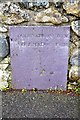
Old Milestone by the former A487, Gwynfa, Penygroes, Llanllyfni Parish
By the UC road (was the A487), in parish of Llanllyfni (Gwynedd District), Gwynfa, northern edge of Penygroes, set into stone wall, East side of road.
Inscription reads:-
TO { CARNARVON 6 M
.. { TREMADOC 13 M
Grade II listed by Cadw. Reference Number: 23696
https://cadwpublic-api.azurewebsites.net/reports/listedbuilding/FullReport?lang=&id=23696
Surveyed
Milestone Society National ID: CAE_CVTM06
Image: © Christopher Leather
Taken: 20 May 2024
0.06 miles
4
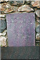
Old Milestone by the former A487, Gwynfa, Penygroes, Llanllyfni Parish
By the UC road (was the A487), in parish of Llanllyfni (Gwynedd District), Gwynfa, northern edge of Penygroes, set into stone wall, East side of road.
Inscription reads:-
TO { CARNARVON 6 M
.. { TREMADOC 13 M
Grade II listed by Cadw. Reference Number: 23696
https://cadwpublic-api.azurewebsites.net/reports/listedbuilding/FullReport?lang=&id=23696
Surveyed
Milestone Society National ID: CAE_CVTM06.
Image: © Milestone Society
Taken: Unknown
0.06 miles
5
Old Slate Milestone
Old slate milestone on what was the A487 at Penygroes, Gwynedd for overall view see http://www.geograph.org.uk/photo/5372594
Image: © Keith Evans
Taken: 29 Apr 2017
0.07 miles
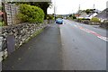
6
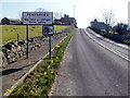
Northern boundary of Penygroes
The road south from the A487 reaches Penygroes, a village in Gwynedd.
Image: © Jaggery
Taken: 24 Mar 2012
0.09 miles
7
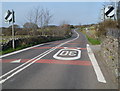
Road north from Penygroes
North of High Street, the 30mph speed limit in the village increases to the National Speed Limit on the road north to the A467.
Image: © Jaggery
Taken: 24 Mar 2012
0.11 miles
9
Former Bethel Sunday School and vestry, Penygroes
Now in residential use, located in Cae Capel Bach on the west side of High Street.
The former chapel http://www.geograph.org.uk/photo/3467883 is a few metres beyond the left edge of the view.
Image: © Jaggery
Taken: 24 Mar 2012
0.14 miles
10
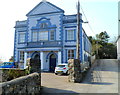
Former Bethel chapel, Penygroes
Now in residential use, the former Methodist chapel is located in Cae Capel Bach on the west side of High Street. The two years on the facade, 1860 and 1901, are probably the dates of the original chapel and its rebuild. The building which formerly housed the Sunday School and vestry is opposite. http://www.geograph.org.uk/photo/3467886
Image: © Jaggery
Taken: 24 Mar 2012
0.15 miles