IMAGES TAKEN NEAR TO
Rhyd Y Berw, CAERNARFON, LL54 5AF
Introduction
This page details the photographs taken nearby to Rhyd Y Berw, LL54 5AF by members of the Geograph project.
The Geograph project started in 2005 with the aim of publishing, organising and preserving representative images for every square kilometre of Great Britain, Ireland and the Isle of Man.

There are currently over 7.5m images from over14,400 individuals and you can help contribute to the project by visiting https://www.geograph.org.uk
Image Map (Loading...)


Getting Data...Please wait
Leaflet Map data © OpenStreetMap
Images are licensed for reuse under creativecommons.org/licenses/by-sa/2.0
Notes
- Clicking on the map will re-center to the selected point.
- The higher the marker number, the further away the image location is from the centre of the postcode.
Image Listing (78 Images Found)
Images are licensed for reuse under creativecommons.org/licenses/by-sa/2.0
Image
Details
Distance
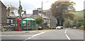
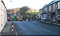
2
Approaching the crossroads at Llanaelhaearn
Image: © Eric Jones
Taken: 9 Feb 2008
0.02 miles
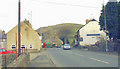
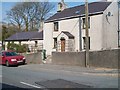
4
Llanaelhaearn village centre
The A499 passes behind the stop sign and lurking in the shadows is the Cadw grade-II listed K6 phone box (listing 4611 https://cadwpublic-api.azurewebsites.net/reports/listedbuilding/FullReport?lang=&id=4611 ).
Image: © Bill Harrison
Taken: 15 Jul 2022
0.02 miles
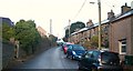
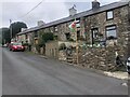
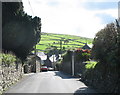
6
The crossroads at the centre of Llanaelhaearn
Here the A499 is crossed by a minor road. The building on the right, now a cafe, was the Tafarn yr Eifl (The Rivals Inn).
Image: © Eric Jones
Taken: 16 Oct 2010
0.03 miles
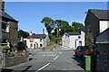
8
Rhyd Ychain Cottage, Llanaelhaearn
Rhyd Ychain means "oxenford"
Image: © Eric Jones
Taken: 23 Apr 2010
0.04 miles
9
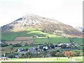
The Village from Stryd yr Eglwys
Stryd yr Eglwys links the B4417 and the A499. Before the construction of the new portion of the B4417, Stryd yr Eglwys formed part of that road. The main street of Llanaelhaearn has developed along the A499 Caernarfon to Pwllheli road which runs along the floor of the col. The roofs of houses in the main street can be seen in the middle distance. The slope opposite is that of Moelfre.
Image: © Eric Jones
Taken: 26 Sep 2006
0.04 miles
10
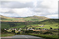
Llanaelhaearn: the village from the south west
Seen from the B4417 road. The main road, the A499 from Caernarfon to Pwllheli, runs through Llanaelhaearn
Image: © Martin Bodman
Taken: 17 Sep 2005
0.04 miles