IMAGES TAKEN NEAR TO
Rhiw, PWLLHELI, LL53 8AH
Introduction
This page details the photographs taken nearby to LL53 8AH by members of the Geograph project.
The Geograph project started in 2005 with the aim of publishing, organising and preserving representative images for every square kilometre of Great Britain, Ireland and the Isle of Man.

There are currently over 7.5m images from over14,400 individuals and you can help contribute to the project by visiting https://www.geograph.org.uk
Image Map
Images are licensed for reuse under creativecommons.org/licenses/by-sa/2.0
Notes
- Clicking on the map will re-center to the selected point.
- The higher the marker number, the further away the image location is from the centre of the postcode.
Image Listing (13 Images Found)
Images are licensed for reuse under creativecommons.org/licenses/by-sa/2.0
Image
Details
Distance
1
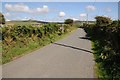
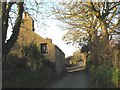
Country road near Tyddyn Meirion
Country road near Tyddyn Meirion near Rhiw on the Lleyn peninsula.
Image: © Philip Halling
Taken: 15 Aug 2014
0.09 miles
2
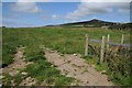
Field entrance
Entrance to a pasture field near Llanfaelrhys.
Image: © Philip Halling
Taken: 15 Aug 2014
0.09 miles
3
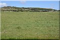
Field cut for silage
Field cut for silage near Llanfaelrhys.
Image: © Philip Halling
Taken: 15 Aug 2014
0.11 miles
5
Tyddyn Meirion from Gallt y Rhiw
Once famous for its manganese mine, Tyddyn Meirion is now the home of the Coed Llyn tree nursery.
Image
Image: © Eric Jones
Taken: 9 Nov 2007
0.15 miles
6
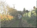
Approaching Tyddyn Meirion from the direction of Ty Canol
Tyddyn Meirion, a former smallholding and the site of the Tyddyn Meirion manganese mine, is now a nursery specializing in growing young trees.
http://www.rhiw.com/y_pentra/coed_llyn/coed_llyn_catalogue.htm
Image: © Eric Jones
Taken: 9 Nov 2007
0.16 miles
7
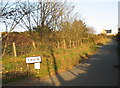
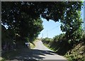
Gallt y Rhiw hill
This is the road linking Y Rhiw with Aberdaron. The village is located on the top of the hill.
Image: © Eric Jones
Taken: 9 Nov 2007
0.17 miles
8
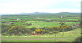
Bocage landscape extending west of Rhiw
This landscape extends westwards towards Aberdaron.
Image: © Eric Jones
Taken: 16 Nov 2007
0.19 miles
9
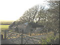
Ruined former farm buildings at Ty Canol
Ty Canol is a former small holding. With land amalgamation the farm buildings became redundant.
Image
Image: © Eric Jones
Taken: 9 Nov 2007
0.20 miles
10
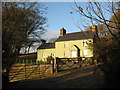
Ty Canol
This former small holding was the site of the Ty Canol Manganese Mine.
Image
Image: © Eric Jones
Taken: 9 Nov 2007
0.20 miles