IMAGES TAKEN NEAR TO
Llangybi, PWLLHELI, LL53 6DZ
Introduction
This page details the photographs taken nearby to LL53 6DZ by members of the Geograph project.
The Geograph project started in 2005 with the aim of publishing, organising and preserving representative images for every square kilometre of Great Britain, Ireland and the Isle of Man.

There are currently over 7.5m images from over14,400 individuals and you can help contribute to the project by visiting https://www.geograph.org.uk
Image Map
Images are licensed for reuse under creativecommons.org/licenses/by-sa/2.0
Notes
- Clicking on the map will re-center to the selected point.
- The higher the marker number, the further away the image location is from the centre of the postcode.
Image Listing (17 Images Found)
Images are licensed for reuse under creativecommons.org/licenses/by-sa/2.0
Image
Details
Distance
1
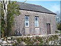
Capel Brynengan chapel
Richard Jones, the grandfather of Bryn Terfel, was the "codwr canu" (the cantor) at this Calvinistic Methodist chapel. As a child Bryn also often sang at this remote chapel in the hills.
http://www.last.fm/music/Bryn+Terfel
Image: © Eric Jones
Taken: 10 Apr 2010
0.04 miles
2
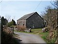
Capel Bryn Engan from the north
This is the third Calvinist chapel built on this site. The first and second chapels were built in 1777 and 1826 and the present chapel in 1908. In the 18thC the chapel was also used as a school house. The carpenter and Calvinist exhorter Robert Jones (1745-1829) of Suntur, Rhoslan was headmaster here at one time.
http://wbo.llgc.org.uk/en/s-JONE-ROB-1745.html
The chapel house has been demolished.
Image: © Eric Jones
Taken: 10 Apr 2010
0.04 miles
3
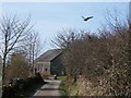
A startled pheasant near Bryn Engan chapel
Image: © Eric Jones
Taken: 10 Apr 2010
0.04 miles
4
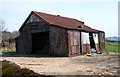
Hen Ysgol Bryn-engan Old School
This building - which I mistook for a farm building and which stands opposite Capel Bryn-engan chapel - was in fact the Bryn-engan Primary School. I am grateful to Ms G. Williams for the information. Ms Williams writes: "This is not an old barn, it used to be the Brynengan Primary School. The school closed it doors in September 1964 and I was one of the five pupils that were there on that day. The structure of the building remains the same as I remember it. I was also a member of the Bryn-engan Chapel and attended Sunday School there. My sister remains a member of the chapel."
Image: © Eric Jones
Taken: 10 Apr 2010
0.07 miles
5
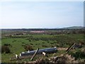
The view south from near Beudy Drylliau
The view extends towards Tremadog Bay. The hill on the right is Carn Pentyrch which rises above the holy well at Llangybi.
Image: © Eric Jones
Taken: 10 Apr 2010
0.13 miles
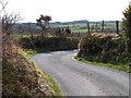
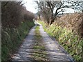
7
The northern section of the Bryn Engan lane
Image: © Eric Jones
Taken: 10 Apr 2010
0.19 miles
8

Rough grazing south of the Hendre Cennin road
Image: © Eric Jones
Taken: 10 Apr 2010
0.22 miles
9
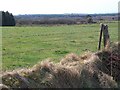
Pasture land and forest plantations south of the Llangybi road
Image: © Eric Jones
Taken: 10 Apr 2010
0.22 miles
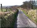
10
View south along the Llangybi road south of the junction with Lon Brychyni
Image: © Eric Jones
Taken: 10 Apr 2010
0.23 miles