IMAGES TAKEN NEAR TO
Abererch Road, PWLLHELI, LL53 5YU
Introduction
This page details the photographs taken nearby to Abererch Road, LL53 5YU by members of the Geograph project.
The Geograph project started in 2005 with the aim of publishing, organising and preserving representative images for every square kilometre of Great Britain, Ireland and the Isle of Man.

There are currently over 7.5m images from over14,400 individuals and you can help contribute to the project by visiting https://www.geograph.org.uk
Image Map
Images are licensed for reuse under creativecommons.org/licenses/by-sa/2.0
Notes
- Clicking on the map will re-center to the selected point.
- The higher the marker number, the further away the image location is from the centre of the postcode.
Image Listing (99 Images Found)
Images are licensed for reuse under creativecommons.org/licenses/by-sa/2.0
Image
Details
Distance
1
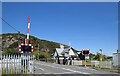
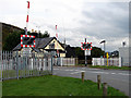
AHB (automatic half-barrier) level crossing, Pwllheli
The road leads to the marina with an outcrop of the Allt Fawr rhyolitic tuff formation in the background, being igneous bedrock formed between 458.4 and 449 million years ago during the Ordovician period.
Image: © Bill Harrison
Taken: 9 Jul 2022
0.01 miles
2
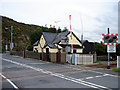
Gatekeeper's cottage
The level crossing was constructed when the railway line was extended to the current terminus in 1909 from the original 1869 terminus. The barriers are now fully automatic so the cottage is now in private hands.
Image: © John Lucas
Taken: 30 Oct 2008
0.01 miles
3
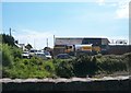
Shell UK Oil Distribution Depot, Glan-y-don, Pwllheli
Image: © Eric Jones
Taken: 17 Jun 2010
0.01 miles
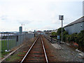
5
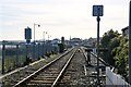
Pwllheli : Railway Track
The Cambrian Line.
Image: © Lewis Clarke
Taken: 20 Apr 2024
0.02 miles
6
Yr hen orsaf Pwllheli Old station
This crossing is near the site of the original Pwllheli station on the Cambrian Railway
Image: © Alan Fryer
Taken: 6 Mar 2007
0.02 miles
7
Start of the final kilometre on the Cambrian Coast line
This view is taken from the Old Goods Station Crossing in the direction of Pwllheli's passenger station
Image: © Eric Jones
Taken: 25 Jun 2010
0.02 miles
8
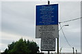
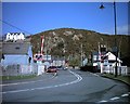
Arwydd wrth y Groesfan - Sign at the Level Crossing
A useful explanation of the terms "large" and "slow" - though a driver would have to stop to read all the information here. The first level crossing after trains leave Pwllheli station.
Image: © Alan Fryer
Taken: 2 Sep 2007
0.02 miles
9
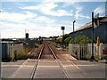
The final section of the Cambrian Coast Line
The final section, both geographically and historically. Viewed from the level crossing at the east of Pwllheli, this is the 1909 extension of the line into the new terminus and is built on reclaimed land at the north of Pwllheli harbour. It seems hardly credible in these days of a standard 2-hourly service pattern, but the Great Western Railway doubled-tracked this section to increase capacity. The double track is now just a long run-round loop and is only used to accommodate locomotive hauled charter trains and the summer steam specials.
Image: © John Lucas
Taken: 30 Oct 2008
0.02 miles