IMAGES TAKEN NEAR TO
Bro Gwgan, GARNDOLBENMAEN, LL51 9AL
Introduction
This page details the photographs taken nearby to Bro Gwgan, LL51 9AL by members of the Geograph project.
The Geograph project started in 2005 with the aim of publishing, organising and preserving representative images for every square kilometre of Great Britain, Ireland and the Isle of Man.

There are currently over 7.5m images from over14,400 individuals and you can help contribute to the project by visiting https://www.geograph.org.uk
Image Map (Loading...)


Getting Data...Please wait
Leaflet Map data © OpenStreetMap
Images are licensed for reuse under creativecommons.org/licenses/by-sa/2.0
Notes
- Clicking on the map will re-center to the selected point.
- The higher the marker number, the further away the image location is from the centre of the postcode.
Image Listing (14 Images Found)
Images are licensed for reuse under creativecommons.org/licenses/by-sa/2.0
Image
Details
Distance
1
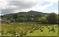
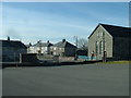
Tai Fforddiadwy Garndolbenmaen Affordable Housing
Ten houses have just been completed on land sold to the Tai Eryri Housing Association at below market value by Gwynedd Council. See http://taieryri.co.uk/pdf/Datganiad%20Garn%206%2006%2007.pdf
Image: © Alan Fryer
Taken: 4 Nov 2007
0.00 miles
2
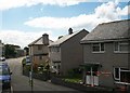
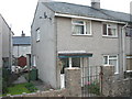
Houses at Stad Pedr Fardd
This Local Authority Estate is named after a 19thc local boy made good, Peter Jones better known as Pedr Fardd (Peter the Bard).
Image: © Eric Jones
Taken: 14 Jun 2010
0.03 miles
3
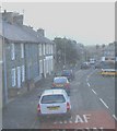
Road congestion in the centre of Garndolbenmaen
The double decker has had to mount the pavement to allow oncoming traffic to pass.
Image: © Eric Jones
Taken: 5 Jan 2008
0.04 miles
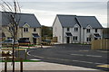
4
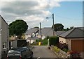
New houses at Garn
Garndolbenmaen is referred to locally as "Garn". Garn has seen an expansion in recent years with the building of new houses.
Image: © Eric Jones
Taken: 14 Jun 2010
0.04 miles
5
Stad Pedr Fardd Estate, Y Garn
This local authority estate is named after a local poet Peter Jones (1775-1845) whose nom de plume was Pedr Fardd (Peter the poet). Garndolbenmaen is referred to locally simply as Y Garn.
http://yba.llgc.org.uk/en/s-JONE-PET-1775.html
Image: © Eric Jones
Taken: 18 Jul 2007
0.06 miles
7
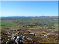
Looking towards Garndolbenmaen from the summit of Graig-y-garn
Image: © Meirion
Taken: 26 Mar 2012
0.07 miles
8
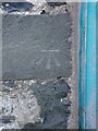
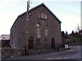
Benchmark on Capel Horeb, Garndolbenmaen
This benchmark is located on the NW face of Capel Horeb in Garndolbenmaen & it is shown in the current Ordnance Survey database at a height of 140.7475m above the Newlyn datum. See also: Image
Image: © Meirion
Taken: 27 Jan 2011
0.07 miles
9
Garndolbenmaen village centre
The village is in a charming location, but has some surprisingly 'ordinary' housing.
Image: © David Medcalf
Taken: 10 Feb 2006
0.09 miles