IMAGES TAKEN NEAR TO
Craig Madog, PORTHMADOG, LL49 9TG
Introduction
This page details the photographs taken nearby to Craig Madog, LL49 9TG by members of the Geograph project.
The Geograph project started in 2005 with the aim of publishing, organising and preserving representative images for every square kilometre of Great Britain, Ireland and the Isle of Man.

There are currently over 7.5m images from over14,400 individuals and you can help contribute to the project by visiting https://www.geograph.org.uk
Image Map
Images are licensed for reuse under creativecommons.org/licenses/by-sa/2.0
Notes
- Clicking on the map will re-center to the selected point.
- The higher the marker number, the further away the image location is from the centre of the postcode.
Image Listing (112 Images Found)
Images are licensed for reuse under creativecommons.org/licenses/by-sa/2.0
Image
Details
Distance
1
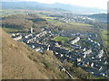
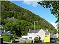
Tremadog village, viewed from Craig-y-Castell
Image: © David Medcalf
Taken: 10 Feb 2008
0.04 miles
2
Along Dublin Street
Looking towards the centre of Tremadog.
Image: © DS Pugh
Taken: 2 Aug 2018
0.05 miles
3
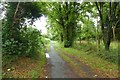
Cycle track to Porthmadog
Leading from Tremadog into Porthmadog.
Image: © DS Pugh
Taken: 2 Aug 2018
0.05 miles
4
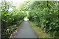
Tremadog to Porthmadog path
Looking along the cycle path through woodland.
Image: © DS Pugh
Taken: 2 Aug 2018
0.05 miles
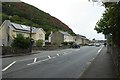
5
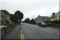
Dublin Street
Looking along Dublin Street in Tremadog.
Image: © DS Pugh
Taken: 2 Aug 2018
0.07 miles
6
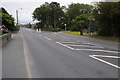
Bus at an eastbound stop, Tremadog
On Dublin Road [the A498].
Image: © Christine Johnstone
Taken: 29 May 2015
0.07 miles
7
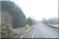
The A487 on the western outskirts of Tremadog
On entering Tremadog this stretch of road becomes Dublin Street. William Madocks who built this town had plans for a turnpike road and a railway line leading through Tremadog to Porthdinllaen Image where a packet port for Dublin would be built. Only the turnpike part of the dream was realised.
Image: © Eric Jones
Taken: 5 Jan 2008
0.07 miles
9
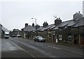
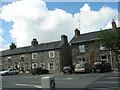
Study in grey (Dublin Street, Tremadog)
An exceptionally grey day even for the vicinity and I have lightened the photo as much as I dare. Each house in the terrace has a separate Cadw grade-II listing, with No. 15 as an example (85316 https://cadwpublic-api.azurewebsites.net/reports/listedbuilding/FullReport?lang=&id=85316 ), which notes that the terrace is probably the earliest surviving structure in Tremadog. Note the 'raked half dormer' roofs and huge chimney breasts. The name Dublin Street refers to the hope in the early 19th Century that this would be on the route to Dublin (via Porth Dinllaen) although Holyhead eventually took that prize.
Image: © Bill Harrison
Taken: 6 Jul 2022
0.07 miles
10
Dublin Street, Tremadog
The A498 approaching Tremadog from the west.
Image: © Philip Halling
Taken: 19 Aug 2011
0.08 miles