IMAGES TAKEN NEAR TO
Snowdon Street, PORTHMADOG, LL49 9PQ
Introduction
This page details the photographs taken nearby to Snowdon Street, LL49 9PQ by members of the Geograph project.
The Geograph project started in 2005 with the aim of publishing, organising and preserving representative images for every square kilometre of Great Britain, Ireland and the Isle of Man.

There are currently over 7.5m images from over14,400 individuals and you can help contribute to the project by visiting https://www.geograph.org.uk
Image Map
Images are licensed for reuse under creativecommons.org/licenses/by-sa/2.0
Notes
- Clicking on the map will re-center to the selected point.
- The higher the marker number, the further away the image location is from the centre of the postcode.
Image Listing (160 Images Found)
Images are licensed for reuse under creativecommons.org/licenses/by-sa/2.0
Image
Details
Distance
1
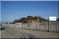
Commercial yard on the edge of Porthmadog
There are many small industrial and commercial premises alongside Snowdon Street on this side of the town. The lump behind has a trig point at 19 metres but it is not accessible. The pillar is visible from the south.
Image: © Bill Boaden
Taken: 25 Mar 2012
0.01 miles
2
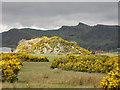
Ynys Cerrig-duon
One of many rocky outcrops in the area which would have been islands before the "Traeth Mawr" was reclaimed from the sea nearly 200 years ago.
Image: © Dewi
Taken: 3 Apr 2003
0.02 miles
3
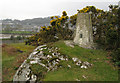
Trig point of Ynys Cerrigduon
Ynys Cerrigduon is a rocky outcrop east of Porthmadog lying just on the south side of the railway; it has this OS trig point. The town of Porthmadog can be seen in the distance.
Image: © Trevor Littlewood
Taken: 4 Apr 2008
0.03 miles
4
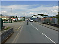
The continuation of Snowdon Street
This used to lead to the Sports Field before the Bypass was built.
Image: © David Medcalf
Taken: 8 Aug 2013
0.03 miles
5
Llyn Bach as the Welsh Highland Railway approaches Porthmadog
Image: © Chris Morgan
Taken: 22 Jul 2014
0.08 miles
6
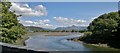
Llyn Bach, Porthmadog, Gwynedd
Seen at low tide, this basin fills at high tide, and is the meeting point of the sea, and the Afon Glaslyn. In addition, a small stream feeds into Llyn Bach from the right of picture. Former warehouses can be seen in the centre of picture, whilst Moel-y-Gest dominates the skyline.
Image: © Peter Trimming
Taken: 30 Apr 2010
0.09 miles
7
Rheilffordd y Cambrian Railway
The Cambrian Railway heads East across Traeth Mawr.
Image: © Alan Fryer
Taken: 19 Apr 2007
0.10 miles
8
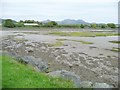
The northern end of Llyn Bach, at low tide
A tidal basin, north of the Cob and on the west bank of the Glaslyn estuary.
Image: © Christine Johnstone
Taken: 30 May 2015
0.10 miles
9
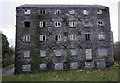
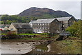
Snowdon Flour Mill
Grade II Listed Snowdon Flour Mill put up for sale in 2016 following collapse of plans for conversion into
27 luxury apartments.
Image: © Arthur C Harris
Taken: 26 Dec 2018
0.10 miles
10
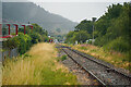
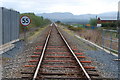
The Cambrian Coast line
Looking towards Porthmadog station from the Snowdon Street level crossing.
Image: © John Lucas
Taken: 23 Jul 2022
0.11 miles