1
Porthmadog - 2013
Porthmadog, Gwynedd, Cambrian Line, Porthmadog Railway Station, Platform 2
Image: © Helmut Zozmann
Taken: 22 Aug 2013
0.05 miles
2
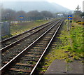
A view west from Porthmadog railway station
A view along the Cambrian Coast line from the edge of Porthmadog railway station. The next station in this direction is Criccieth.
Ahead there are two trackside signs, a yellow arrow on a blue background, pointing across the tracks. Their identifications are MH1236 and MH1240. There are a similar pair of signs at the opposite end of the station. It is likely that their function is to remind train drivers that the double track through the station reverts to single track ahead.
Image: © Jaggery
Taken: 23 Mar 2012
0.07 miles
3
Y Cyt alongside Pensyflog, Porthmadog
Viewed from High Street. Y Cyt, a drainage channel formerly a canal http://www.geograph.org.uk/photo/399161 is at the edge of the residential road named Pensyflog. http://www.geograph.org.uk/photo/2908772
Image: © Jaggery
Taken: 23 Mar 2012
0.08 miles
4
Arriva Train Arrives at Porthmadog, Gwynedd
A class 158 'sprinter', on the service from Pwllheli to Birmingham International, arrives at Porthmadog.
Image: © Peter Trimming
Taken: 30 Sep 2011
0.09 miles
5
Y Cyt / The Cut at Pensyflog, Porthmadog
The access road is also a public footpath. The footpath follows the line of the Gorseddau tramway from distant slate quarries to the harbour, and the tramway itself followed the once-navigable canal between Tremadog and the coast.
Image: © Christine Johnstone
Taken: 29 May 2015
0.09 miles
6
Pensyflog, Porthmadog
This is the SE end of a residential street, Pensyflog, viewed across High Street.
Image: © Jaggery
Taken: 23 Mar 2012
0.10 miles
7
Steps and entrance trilith, Porthmadog War Memorial
The steps and trilith are at the High Street end of a 70 metre long semicircular path leading up to the War Memorial cross. http://www.geograph.org.uk/photo/2908646
Image: © Jaggery
Taken: 23 Mar 2012
0.10 miles
8
Northern end of High Street, Porthmadog
A view from the SE edge of Meadow Drive. The high ground in the distance is at the southern edge of Snowdonia National Park.
Image: © Jaggery
Taken: 23 Mar 2012
0.10 miles
9
Porthmadog Station
Image: © Kevin Williams
Taken: 17 Aug 2012
0.11 miles
10
A Machynlleth bound train enters Porthmadog station
Machynlleth fixed signals 1236 on the left and 1240 on the right.
Image: © John Lucas
Taken: 13 Oct 2016
0.11 miles


