IMAGES TAKEN NEAR TO
East Avenue, PORTHMADOG, LL49 9EL
Introduction
This page details the photographs taken nearby to East Avenue, LL49 9EL by members of the Geograph project.
The Geograph project started in 2005 with the aim of publishing, organising and preserving representative images for every square kilometre of Great Britain, Ireland and the Isle of Man.

There are currently over 7.5m images from over14,400 individuals and you can help contribute to the project by visiting https://www.geograph.org.uk
Image Map
Images are licensed for reuse under creativecommons.org/licenses/by-sa/2.0
Notes
- Clicking on the map will re-center to the selected point.
- The higher the marker number, the further away the image location is from the centre of the postcode.
Image Listing (473 Images Found)
Images are licensed for reuse under creativecommons.org/licenses/by-sa/2.0
Image
Details
Distance
1
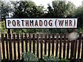
Welsh Highland Railway (Porthmadog) Station
The terminus of the narrow gauge WHR(P) adjacent to the Network Rail's Porthmadog Station on the Cambrian Coast Line.
Image: © David Stowell
Taken: 28 Apr 2006
0.03 miles
2

North side of Cambrian Terrace, Porthmadog
The houses are all on the south side http://www.geograph.org.uk/photo/2895804 of Cambrian Terrace. This side is occupied by a garage.
Image: © Jaggery
Taken: 23 Mar 2012
0.03 miles
3
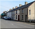
South side of Cambrian Terrace, Porthmadog
This is the residential side of the street. The opposite side is occupied by a garage. http://www.geograph.org.uk/photo/2895803
Image: © Jaggery
Taken: 23 Mar 2012
0.03 miles
4
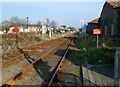
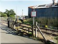
Two tracks into one east of Porthmadog railway station
A few tens of metres east of the level crossing http://www.geograph.org.uk/photo/2908585 at the eastern edge of Porthmadog railway station, two tracks become one track. A white on red sign on the right shows a £1000 penalty for anyone caught trespassing on the railway.
Image: © Jaggery
Taken: 23 Mar 2012
0.03 miles
5
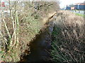
Porthmadog: Y Cyt viewed from a footbridge
A view SE from a footbridge http://www.geograph.org.uk/photo/2908748 along Y Cyt, a drainage channel that was formerly a canal. http://www.geograph.org.uk/photo/399161
Image: © Jaggery
Taken: 23 Mar 2012
0.03 miles
6
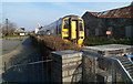
Train leaving Porthmadog - next stop Minffordd
An Arriva Trains Wales service has just left Porthmadog station and passed over the High Street level crossing. http://www.geograph.org.uk/photo/2908947 Next stop is Minffordd station, in 4 minutes. The trailing unit is number 158839.
Image: © Jaggery
Taken: 23 Mar 2012
0.03 miles
7
Porthmadog - 2013
Porthmadog, Gwynedd, Welsh Highland Heritage Railway, Porthmadog Railway Station (WHHR), Cambrian Line, Footpath level crossing
Image: © Helmut Zozmann
Taken: 22 Aug 2013
0.03 miles
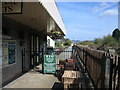
8

Porthmadog - 2013
Porthmadog, Gwynedd, Welsh Highland Heritage Railway, Porthmadog Railway Station (WHHR) interior
Image: © Helmut Zozmann
Taken: 22 Aug 2013
0.03 miles
9
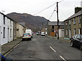
Glaslyn Street, Porthmadog
With Moel-y-Gest (hill) in view.
Image: © John Lucas
Taken: 30 Nov 2016
0.04 miles
10
Porthmadog - 2013
Porthmadog, Gwynedd, Welsh Highland Heritage Railway, Porthmadog Railway Station (WHHR)
Image: © Helmut Zozmann
Taken: 22 Aug 2013
0.04 miles