IMAGES TAKEN NEAR TO
TALYBONT, LL43 2AH
Introduction
This page details the photographs taken nearby to LL43 2AH by members of the Geograph project.
The Geograph project started in 2005 with the aim of publishing, organising and preserving representative images for every square kilometre of Great Britain, Ireland and the Isle of Man.

There are currently over 7.5m images from over14,400 individuals and you can help contribute to the project by visiting https://www.geograph.org.uk
Image Map
Images are licensed for reuse under creativecommons.org/licenses/by-sa/2.0
Notes
- Clicking on the map will re-center to the selected point.
- The higher the marker number, the further away the image location is from the centre of the postcode.
Image Listing (21 Images Found)
Images are licensed for reuse under creativecommons.org/licenses/by-sa/2.0
Image
Details
Distance
1
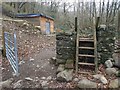
A shed in the wood
Probably a small hydro-electric station.
Image: © David Medcalf
Taken: 16 Feb 2019
0.05 miles
5
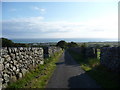
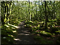
Walled lane down towards Tal-y-bont
The lane here carried nice views out to the sea on a June evening.
Image: © Jeremy Bolwell
Taken: 29 Jun 2011
0.13 miles
6
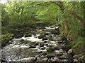
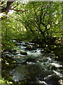
The well named Afon 'Sgethin from the footbridge
Afon Ysgethin ('Sgethin in the local dialect) means "wild watered river".
Image: © Eric Jones
Taken: 16 Aug 2007
0.14 miles
8
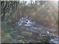
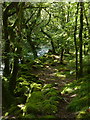
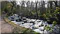
Afon Ysgethin
The Afon Ysgethin running through the wood on its way to the sea, about 1200mtrs to go.
Image: © Allan Sutton
Taken: 9 Apr 2011
0.14 miles
9
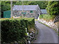
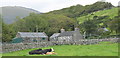
Tyddyn-y-Felin
in Tal-y-bont. Note the massive stones used in the building as with Image nearby.
Image: © Roger W Haworth
Taken: 28 Jul 2006
0.14 miles