IMAGES TAKEN NEAR TO
Pant Y Celyn, BLAENAU FFESTINIOG, LL41 4UH
Introduction
This page details the photographs taken nearby to Pant Y Celyn, LL41 4UH by members of the Geograph project.
The Geograph project started in 2005 with the aim of publishing, organising and preserving representative images for every square kilometre of Great Britain, Ireland and the Isle of Man.

There are currently over 7.5m images from over14,400 individuals and you can help contribute to the project by visiting https://www.geograph.org.uk
Image Map
Images are licensed for reuse under creativecommons.org/licenses/by-sa/2.0
Notes
- Clicking on the map will re-center to the selected point.
- The higher the marker number, the further away the image location is from the centre of the postcode.
Image Listing (71 Images Found)
Images are licensed for reuse under creativecommons.org/licenses/by-sa/2.0
Image
Details
Distance
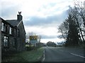
1
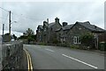
Terrace in Trawsfynydd
Looking towards a terrace along the road to Trawsfynydd village.
Image: © DS Pugh
Taken: 6 Aug 2020
0.00 miles
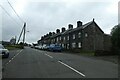
2
Stryd Penygarreg at the North end of Trawsfynydd
Image: © Eric Jones
Taken: 28 Jul 2007
0.03 miles
4
Field below Pen y Gareg Street
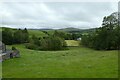
Looking down on a field below the road in Trawsfynydd.
Image: © DS Pugh
Taken: 6 Aug 2020
0.07 miles
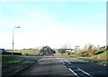
5
Road junction with A470
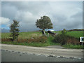
North of Trawsfynydd this is where the road from the village joins the main A470
Image: © John Firth
Taken: 6 Oct 2010
0.07 miles
6
Berntsen, Trawsfynydd
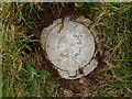
This Ordnance Survey berntsen is located in a small grassy verge in Trawsfynydd. It is an auxiliary to the fundamental benchmark which lies nearby.
Image: © Meirion
Taken: 21 Mar 2012
0.07 miles
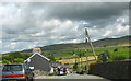
7
Pen y Gareg Street, Trawsfynydd
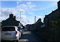
This is the main street through the village.
Image: © Eirian Evans
Taken: 26 Apr 2009
0.07 miles
8
Pen y Gareg Street
Looking along Pen y Gareg Street in Trawsfynydd.
Image: © DS Pugh
Taken: 6 Aug 2020
0.08 miles
9
Ordnance Survey Cut Mark
This OS cut mark can be found on Penrallt, Pen-y-gareg Street. It marks a point 235.939m above mean sea level.
Image: © Adrian Dust
Taken: 11 May 2016
0.08 miles