IMAGES TAKEN NEAR TO
Bontddu, DOLGELLAU, LL40 2UL
Introduction
This page details the photographs taken nearby to LL40 2UL by members of the Geograph project.
The Geograph project started in 2005 with the aim of publishing, organising and preserving representative images for every square kilometre of Great Britain, Ireland and the Isle of Man.

There are currently over 7.5m images from over14,400 individuals and you can help contribute to the project by visiting https://www.geograph.org.uk
Image Map
Images are licensed for reuse under creativecommons.org/licenses/by-sa/2.0
Notes
- Clicking on the map will re-center to the selected point.
- The higher the marker number, the further away the image location is from the centre of the postcode.
Image Listing (18 Images Found)
Images are licensed for reuse under creativecommons.org/licenses/by-sa/2.0
Image
Details
Distance
1
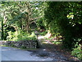
Bontddu
A very steep road/footpath near Fiddlers Elbow.
Image: © alan fairweather
Taken: 9 Jul 2007
0.06 miles
2
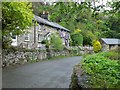
Graig Fawr Cottages, Bontddu
A pretty row of cottages, just off the A496 east of Bontddu.
Image: © Eirian Evans
Taken: 10 May 2012
0.06 miles
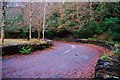
3
Fiddler's Elbow
Lle parcio a safle picnic / Parking area and Picnic site.
Image: © Ian Medcalf
Taken: 3 May 2014
0.07 miles
4
The "Fiddler's Elbow" Bridge
I have a 1920's postcard of this view when the Dolgellau to Abermaw road had to negotiate this tight turn (the road was even narrower then) now long by-passed. The inside of the curve is now picnic area. A good starting point for walks up into Cwm Mynach.
Image: © John Haynes
Taken: 1 Dec 2009
0.08 miles
5
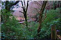
Looking back toward the "Fiddler's Elbow" picnic site
The track from the picnic site rapidly gains height affording this view back through the invading Rhododendron.
Image: © John Haynes
Taken: 1 Dec 2009
0.09 miles
6
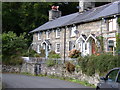
Graig Fawr Cottages.
This attractive terrace is only just in SH6719!
Image: © Hefin Richards
Taken: 24 Sep 2006
0.09 miles
7
The Track to Coed Garth Gell
Coed Garth Gell is an RSPB reserve.
http://google.rspb.org.uk/search?q=Coed+Garth+Gell&site=default_collection&getfields=title.type.icon.description&client=rspb2&proxystylesheet=rspb2&output=xml_no_dtd&sort=date%3AD%3AL%3Ad1&spell=1&proxyreload=0&entqr=0&ud=1&oe=UTF-8&ie=UTF-8&x=42&y=21
Image: © John Haynes
Taken: 1 Dec 2009
0.09 miles
8
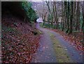
Track down to "Fiddler's Elbow"
The steep tarmac track down to the A496. It's always a good sign when there is a green "bloom" in the centre of a track.
Image: © John Haynes
Taken: 1 Dec 2009
0.10 miles
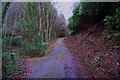
9
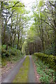
Coed Muriau-Cochion Wood
Trac a llwybr cyhoeddus yng Nghoed Muriau-Cochion / A track and public footpath in Muriau-Cochion Wood.
Image: © Ian Medcalf
Taken: 3 May 2014
0.14 miles
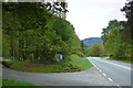
10
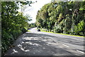
The A496 looking towards Barmouth near Bontddu
Image: © Mick Malpass
Taken: 6 Oct 2012
0.17 miles