IMAGES TAKEN NEAR TO
Bontddu, DOLGELLAU, LL40 2TU
Introduction
This page details the photographs taken nearby to LL40 2TU by members of the Geograph project.
The Geograph project started in 2005 with the aim of publishing, organising and preserving representative images for every square kilometre of Great Britain, Ireland and the Isle of Man.

There are currently over 7.5m images from over14,400 individuals and you can help contribute to the project by visiting https://www.geograph.org.uk
Image Map
Images are licensed for reuse under creativecommons.org/licenses/by-sa/2.0
Notes
- Clicking on the map will re-center to the selected point.
- The higher the marker number, the further away the image location is from the centre of the postcode.
Image Listing (9 Images Found)
Images are licensed for reuse under creativecommons.org/licenses/by-sa/2.0
Image
Details
Distance
2
Afon Cwm-mynach
Seen here above Taicynhaeaf, as it commences a steep descent to the Mawddach estuary.
Image: © Nigel Brown
Taken: 23 Jan 2014
0.01 miles
3
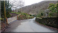
A field squeezed in between the river and the road
Image: © David Medcalf
Taken: 15 Aug 2020
0.05 miles
4
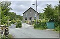
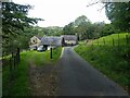
Old Chapel
An old Chapel which a sign on the wall describes as Capel Soar.
Image: © Chris Thomas-Atkin
Taken: 14 Jun 2021
0.11 miles
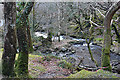
5
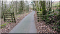
Boundary in Cwm Mynach
Just to the south of Ty'n-y-coed, still marked as gated on current maps but the gate stands disused by the bank. There are other gates on this road through the valley which are still in use.
Image: © John Lucas
Taken: 5 Jan 2019
0.11 miles
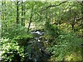
7
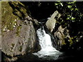
Coed Garth Gell Nature Reserve
Waterfall in the stream through Coed Garth Gell nature reserve.
Image: © Peter Shone
Taken: 7 Aug 2004
0.17 miles
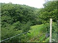
8
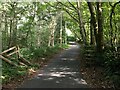
Descending towards Pont Borthwnog from Cwm-mynach
A steep descent down the valley which is marked as such by the OS.
Image: © John Lucas
Taken: 5 Jan 2019
0.22 miles