IMAGES TAKEN NEAR TO
Derwen Deg, DOLGELLAU, LL40 2TH
Introduction
This page details the photographs taken nearby to Derwen Deg, LL40 2TH by members of the Geograph project.
The Geograph project started in 2005 with the aim of publishing, organising and preserving representative images for every square kilometre of Great Britain, Ireland and the Isle of Man.

There are currently over 7.5m images from over14,400 individuals and you can help contribute to the project by visiting https://www.geograph.org.uk
Image Map
Images are licensed for reuse under creativecommons.org/licenses/by-sa/2.0
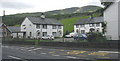
Notes
- Clicking on the map will re-center to the selected point.
- The higher the marker number, the further away the image location is from the centre of the postcode.
Image Listing (95 Images Found)
Images are licensed for reuse under creativecommons.org/licenses/by-sa/2.0
Image
Details
Distance
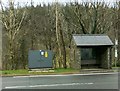
2
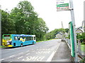
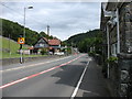
The stop for north-bound buses at Y Ganllwyd
The bus on the other side of the road is the south-bound Welsh Government sponsored Arriva X32 Bangor to Aberystwyth express bus (with direct connection on to Cardiff). The bus bears the Welsh Assembly Government's dragon logo.
Image: © Eric Jones
Taken: 31 Aug 2007
0.01 miles
3
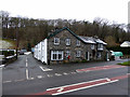
Private house in Ganllwyd
Viewed from the bus shelter. As I waited for the next bus, the look of this building gave the impression that it had a previous use. Firstly I thought that it might have been an inn but inspection of old maps showed that it had been the Ganllwyd post office and is marked as such on the 1889 25" map. A datestone on the gable carries the date 1866. A postbox still stands by the building, marking its previous use.
Image: © John Lucas
Taken: 23 Jan 2019
0.01 miles
4
Milestone
Milestone on the A.470 at Ganllwyd, Gwynedd for overall view see http://www.geograph.org.uk/photo/5375263
Image: © Keith Evans
Taken: 28 Apr 2017
0.02 miles
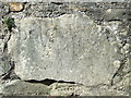
5
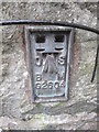
Ordnance Survey Flush Bracket (G2604)
This OS Flush Bracket can be found on the old Post Office building. It marks a point 51.759m above mean sea level.
Image: © Adrian Dust
Taken: 28 Mar 2016
0.02 miles
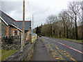
6
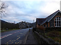
The A470 road through Ganllwyd
The building of Ysgol Ganllwyd stands on the right but sadly closed at the end of the 2018 summer term.
Image: © John Lucas
Taken: 5 Jan 2019
0.02 miles
7
Dolgellau 5
Milepost in wall lower right on the A.470 at Ganllwyd, Gwynedd for close up view see http://www.geograph.org.uk/photo/5375258
Image: © Keith Evans
Taken: 28 Apr 2017
0.02 miles
8
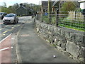
Ganllwyd village
The A470 passes through Ganllwyd, and understandably is subject to speed restrictions, especially at the start and end of the school day.
Image: © David Purchase
Taken: 16 Aug 2015
0.03 miles
10
The A470 road through Ganllwyd
The now closed Ysgol Ganllwyd is on the left.
Image: © John Lucas
Taken: 6 Feb 2019
0.03 miles