IMAGES TAKEN NEAR TO
Pencefn Road, DOLGELLAU, LL40 2ES
Introduction
This page details the photographs taken nearby to Pencefn Road, LL40 2ES by members of the Geograph project.
The Geograph project started in 2005 with the aim of publishing, organising and preserving representative images for every square kilometre of Great Britain, Ireland and the Isle of Man.

There are currently over 7.5m images from over14,400 individuals and you can help contribute to the project by visiting https://www.geograph.org.uk
Image Map
Images are licensed for reuse under creativecommons.org/licenses/by-sa/2.0
Notes
- Clicking on the map will re-center to the selected point.
- The higher the marker number, the further away the image location is from the centre of the postcode.
Image Listing (6 Images Found)
Images are licensed for reuse under creativecommons.org/licenses/by-sa/2.0
Image
Details
Distance
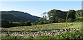
2
Dolgellau golf course
Displaying typical walker-friendly sign
Photograph taken on day 13 of my cross-Wales walk detailed at https://www.trailman.co.uk/wales/across-wales/devils-bridge-to-llanfairfechan/
Previous shot Image, next Image
Image: © Peter Aylmer
Taken: 15 Oct 2005
0.04 miles
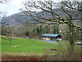
4
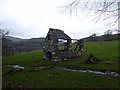
A ruin on farmland near Dolgellau
The internet is quite shy about identifying it and its purpose. It is shown on early OS large scale maps but without description. Given the proximity of the stream it may well have been a water mill.
Image: © John Lucas
Taken: 6 Feb 2019
0.18 miles
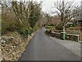
5
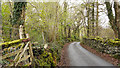
Minor road north of Dolgellau
The road is part of the National Cycle Network; route No. 8.
Image: © Trevor Littlewood
Taken: 18 Apr 2012
0.23 miles