IMAGES TAKEN NEAR TO
Llanfachreth, DOLGELLAU, LL40 2EG
Introduction
This page details the photographs taken nearby to LL40 2EG by members of the Geograph project.
The Geograph project started in 2005 with the aim of publishing, organising and preserving representative images for every square kilometre of Great Britain, Ireland and the Isle of Man.

There are currently over 7.5m images from over14,400 individuals and you can help contribute to the project by visiting https://www.geograph.org.uk
Image Map
Images are licensed for reuse under creativecommons.org/licenses/by-sa/2.0
Notes
- Clicking on the map will re-center to the selected point.
- The higher the marker number, the further away the image location is from the centre of the postcode.
Image Listing (5 Images Found)
Images are licensed for reuse under creativecommons.org/licenses/by-sa/2.0
Image
Details
Distance
1
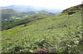
View across a bracken infested hillside towards Mynydd Ty isaf
The Nannau Hall parkland between Foel Offrwm hill and Llyn Cynwch and Foel Cynwch can be seen in the middleground.
Image: © Eric Jones
Taken: 18 Jul 2007
0.18 miles
3
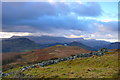
Mynydd Ty-isaf
Golygfa dros Mynydd Ty-isaf i Foel Offrwm a Llyn Cynwch (smotyn bach yng nghanol y llun) gyda Cadair Idris yn y cymylau / A view over Mynydd Ty-isaf to Foel Offrwm and Llyn Cynwch (small speck in the centre of the photo) with Cadair Idris in the clouds.
Image: © Ian Medcalf
Taken: 11 Jan 2014
0.22 miles
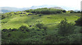
4
Hillside above the forest
The hill in the middleground right is Mynydd Ty-Isaf, while the rounded hill, centre, is Moel Offrwm. Cader Idris forms the background.
Image: © Eric Jones
Taken: 18 Jul 2007
0.23 miles
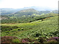
5
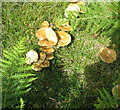
Fungi and bracken fronds at the forest edge
Image: © Eric Jones
Taken: 18 Jul 2007
0.23 miles