IMAGES TAKEN NEAR TO
Rhydymain, DOLGELLAU, LL40 2BU
Introduction
This page details the photographs taken nearby to LL40 2BU by members of the Geograph project.
The Geograph project started in 2005 with the aim of publishing, organising and preserving representative images for every square kilometre of Great Britain, Ireland and the Isle of Man.

There are currently over 7.5m images from over14,400 individuals and you can help contribute to the project by visiting https://www.geograph.org.uk
Image Map
Images are licensed for reuse under creativecommons.org/licenses/by-sa/2.0
Notes
- Clicking on the map will re-center to the selected point.
- The higher the marker number, the further away the image location is from the centre of the postcode.
Image Listing (16 Images Found)
Images are licensed for reuse under creativecommons.org/licenses/by-sa/2.0
Image
Details
Distance
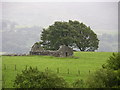
6
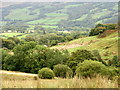
View downslope in the direction of the outbuildings of Hafod Feredydd Farm
Image: © Eric Jones
Taken: 31 Aug 2007
0.13 miles
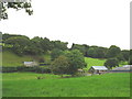
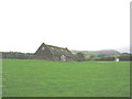
9
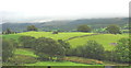
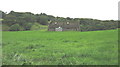
Farmland at Ysgubor-newydd
The photo also shows a ruined barn and a couple of field-clearance cairns.
Image: © Eric Jones
Taken: 31 Aug 2007
0.16 miles