IMAGES TAKEN NEAR TO
Penmaenpool, DOLGELLAU, LL40 1YE
Introduction
This page details the photographs taken nearby to LL40 1YE by members of the Geograph project.
The Geograph project started in 2005 with the aim of publishing, organising and preserving representative images for every square kilometre of Great Britain, Ireland and the Isle of Man.

There are currently over 7.5m images from over14,400 individuals and you can help contribute to the project by visiting https://www.geograph.org.uk
Image Map
Images are licensed for reuse under creativecommons.org/licenses/by-sa/2.0
Notes
- Clicking on the map will re-center to the selected point.
- The higher the marker number, the further away the image location is from the centre of the postcode.
Image Listing (7 Images Found)
Images are licensed for reuse under creativecommons.org/licenses/by-sa/2.0
Image
Details
Distance
1
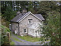
Ty'n y Graig.
Situated off a brow on the road, Ty'n y Graig is easily missed
Image: © Hefin Richards
Taken: 24 Sep 2006
0.06 miles
2
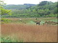
Horses grazing on the Mawddach marshes
Image: © Eirian Evans
Taken: 10 May 2012
0.16 miles
3
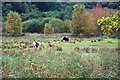
Ponies grazing on Ffridd-llerma Gower
These ponies are brood mares, there are some foals hidden away behind the reedbed.
Image: © John Haynes
Taken: 15 Oct 2009
0.18 miles
4
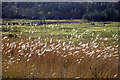
#Blowin' in the wind#
Grass on Ffridd-llerma Gower near Penmaenpool - salt marsh beside Afon Mawddach.
Image: © John Lucas
Taken: 31 Mar 2022
0.21 miles
5
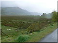
The marshes of the Mawddach
Looking southwest from the Mawddach Trail, Cadair Idris on the horizon.
Image: © Eirian Evans
Taken: 10 May 2012
0.23 miles
6
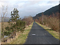
The Mawddach Trail
Looking in the direction of Penmaenpool from near the end of the long straight section to the west of Penmaenpool.
Image: © John Lucas
Taken: 17 Dec 2008
0.23 miles
7
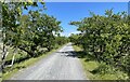
Mawddach Trail
The trail at this point is lined by single trees as it approaches Penmaenpool.
Image: © Chris Thomas-Atkin
Taken: 12 Jun 2021
0.25 miles