IMAGES TAKEN NEAR TO
Friog, FAIRBOURNE, LL38 2RX
Introduction
This page details the photographs taken nearby to LL38 2RX by members of the Geograph project.
The Geograph project started in 2005 with the aim of publishing, organising and preserving representative images for every square kilometre of Great Britain, Ireland and the Isle of Man.

There are currently over 7.5m images from over14,400 individuals and you can help contribute to the project by visiting https://www.geograph.org.uk
Image Map
Images are licensed for reuse under creativecommons.org/licenses/by-sa/2.0
Notes
- Clicking on the map will re-center to the selected point.
- The higher the marker number, the further away the image location is from the centre of the postcode.
Image Listing (55 Images Found)
Images are licensed for reuse under creativecommons.org/licenses/by-sa/2.0
Image
Details
Distance
1
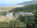
Bryn-Meirig steading
Looking across from the path up to the Golwen slate quarry the house and steading at Bryn-Meirig, with the mix of old and new buildings, looks out towards the sea.
Image: © John Haynes
Taken: 16 May 2012
0.11 miles
2
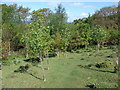
Recently planted broad leaf trees
A good selection of trees including some sessile oaks (Quercus petraea) which is the favoured oak forest tree of the temperate rain forest. Image]
Image: © John Haynes
Taken: 16 May 2012
0.11 miles
4
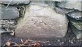
Ordnance Survey Cut Mark
This OS cut mark can be found on the chapel wall. It marks a point 4.841m above mean sea level.
Image: © Adrian Dust
Taken: 18 Feb 2018
0.11 miles
5
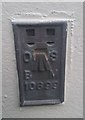
Ordnance Survey Flush Bracket (10699)
This OS Flush Bracket can be found on the SE face of the chapel. It marks a point 7.032m above mean sea level.
Image: © Adrian Dust
Taken: 18 Feb 2018
0.11 miles
6
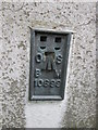
Ordnance Survey Flush Bracket (10699)
This OS Flush Bracket can be found on the SE face of the Saron Chapel. It marks a point 7.032m above mean sea level.
Image: © Adrian Dust
Taken: 25 Jul 2015
0.11 miles
7
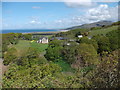
Lle Hwyl farmstead
Above Friog with a view of Barmouth Bay.
Image: © John Lucas
Taken: 8 Aug 2006
0.11 miles
8
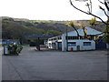
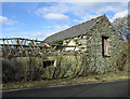
Abandoned petrol station at Friog
Not a busy road out of the tourist season so volumes of fuel sold are low and the margins are small. Modern cars are built with big tanks and many kms per litre so a weekend visitor leaving home with a full tank will get out and back without thinking about buying fuel.
Image: © John Haynes
Taken: 16 May 2012
0.11 miles
9
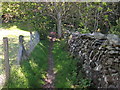
Llwybr Arfordir Cymru starts a long ascent
The Wales Coast Path is heading towards the Golwen slate quarries high on the hill above Friog.
Image]
Image: © John Haynes
Taken: 16 May 2012
0.11 miles
10
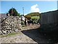
Cattle in Bryn-Meirig steading
A family run farm with holiday lets to support income. The Wales Coast Path goes right through the middle of the steading.
Image: © John Haynes
Taken: 16 May 2012
0.12 miles