IMAGES TAKEN NEAR TO
Talbot Road, FAIRBOURNE, LL38 2LX
Introduction
This page details the photographs taken nearby to Talbot Road, LL38 2LX by members of the Geograph project.
The Geograph project started in 2005 with the aim of publishing, organising and preserving representative images for every square kilometre of Great Britain, Ireland and the Isle of Man.

There are currently over 7.5m images from over14,400 individuals and you can help contribute to the project by visiting https://www.geograph.org.uk
Image Map
Images are licensed for reuse under creativecommons.org/licenses/by-sa/2.0
Notes
- Clicking on the map will re-center to the selected point.
- The higher the marker number, the further away the image location is from the centre of the postcode.
Image Listing (69 Images Found)
Images are licensed for reuse under creativecommons.org/licenses/by-sa/2.0
Image
Details
Distance
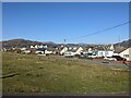
1
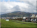
Housing at Fairbourne
With the track of the Faibourne Railway crossing in the foreground and the Southern Rhinogs in the distance.
Image: © John Lucas
Taken: 24 Aug 2016
0.02 miles
2
Fairbourne Railway train approaches Golf Halt
Seen from Penrhyn Drive North.
Image: © DS Pugh
Taken: 19 Jul 2015
0.02 miles
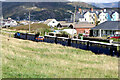
3
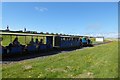
Train at Rowen Centre, Fairbourne
Great attraction for kids.
Image: © Jeremy Bolwell
Taken: 25 Jul 2012
0.03 miles
4
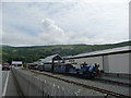
Train passing Talbot Road
Looking from the coast at a Fairbourne Railway train passing Talbot Road. The train is between Beach Halt and Golf Halt, although no stations are currently being served, with round trips only from Fairbourne following reopening after the coronavirus (covid-19) restrictions.
Image: © DS Pugh
Taken: 2 Aug 2020
0.03 miles
6
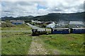
A Fairbourne Railway train heading north
Running alongside Penrhyn Drive.
Image: © John Lucas
Taken: 16 Sep 2021
0.04 miles
7
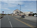
Roadside pub in Fairbourne
'Sunday lunch 4.50 12-3pm' states the signage. Anyone tried it?
Image: © Jeremy Bolwell
Taken: 25 Jul 2012
0.04 miles
8
Ro Wen, Fairbourne
Forms part of the Wales Coast Path. A long row of wartime defence 'dragons' teeth' on the seaward side. The southern Rhinogs above Barmouth in the middle distance.
Image: © John Lucas
Taken: 24 Aug 2016
0.04 miles
9
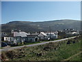
Fairbourne from the Golf Halt
Looking over the village from the Golf Halt platform on the Fairbourne Railway.
http://www.fairbournerailway.com/index.htm
Image: © John Haynes
Taken: 27 Mar 2012
0.05 miles
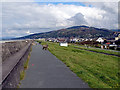
10
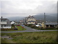
Alyn Road, Fairbourne
Seen from the promenade. The clouds are just beginning to lift from the mountains inland.
Image: © Richard Vince
Taken: 3 Oct 2015
0.05 miles