IMAGES TAKEN NEAR TO
Bryncrug, TYWYN, LL36 9UL
Introduction
This page details the photographs taken nearby to LL36 9UL by members of the Geograph project.
The Geograph project started in 2005 with the aim of publishing, organising and preserving representative images for every square kilometre of Great Britain, Ireland and the Isle of Man.

There are currently over 7.5m images from over14,400 individuals and you can help contribute to the project by visiting https://www.geograph.org.uk
Image Map
Images are licensed for reuse under creativecommons.org/licenses/by-sa/2.0
Notes
- Clicking on the map will re-center to the selected point.
- The higher the marker number, the further away the image location is from the centre of the postcode.
Image Listing (6 Images Found)
Images are licensed for reuse under creativecommons.org/licenses/by-sa/2.0
Image
Details
Distance
1
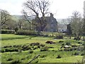
Dolaugwyn
The farm is on flat land of the lower Afon Fathew valley, to the west of Bryn Crug village and stands apart to the west of the farm buildings. The house was built a little before 1620 by Lewis and Anne Gwynne. It is Grade II* listed.
Image: © Eirian Evans
Taken: 26 Mar 2019
0.09 miles
2
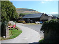
Farm buildings at Dolaugwyn
Some ancient buildings at Dolaugwyn farm. This is a site of historical importance and is consequently marked in 'antique' style lettering on the OS map.
Image: © John Lucas
Taken: 3 Aug 2006
0.15 miles
3
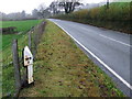
Towyn 3
An old cast iron milepost on the B4405 near to Brycrug, Gwynedd for close up view see http://www.geograph.org.uk/photo/2152388
Image: © Keith Evans
Taken: 4 Nov 2010
0.23 miles
5
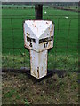
Milepost
An old cast iron milepost near Rhyd-yr-Onen, Gwynedd for overall view see http://www.geograph.org.uk/photo/2152411
Image: © Keith Evans
Taken: 4 Nov 2010
0.24 miles
6
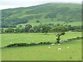
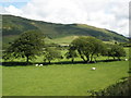
Tree on a field boundary, west of Pandy
On the north side of the Talyllyn Railway.
Image: © Christine Johnstone
Taken: 20 Jun 2016
0.25 miles